Turn raw numbers into a visual map for instant answers. Spreadsheets hide the story. eSpatial clarifies the chaos, helping you spot trends, gaps, and revenue opportunities immediately. Stop scrolling through complex rows. Start making decisions based on clear, actionable maps.
Our Customers Love Mapping With eSpatial
Map on Your Terms
Competitors like Salesforce Maps and Geopointe force you to work inside the CRM. eSpatial doesn't.
The difference
- Inside Salesforce: Seamless integration for daily workflows
- Standalone: Total control for complex mapping projects
The bottom line: You choose the workflow. We provide the map.
Trust Your Maps
Bad data leads to bad decisions. We ensure your maps reflect reality, not the errors in your CRM.
How we do it
- Isolate: Work outside the CRM to bypass messy data records
- Enrich: Layer in external data points your CRM lacks
- Auto-sync: We refresh your maps automatically. No stale data, ever
Powerful, Not Painful
Most mapping tools require training to operate. Ours is built for speed, so you spend time analyzing data, not fighting software.
How it works
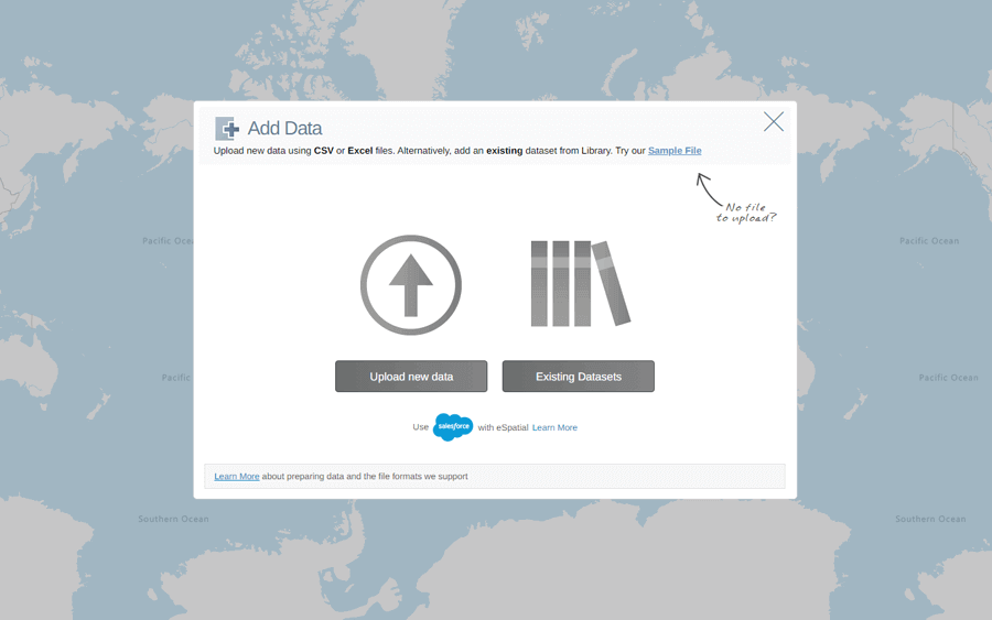
- Upload instantly: Drag and drop your files. No complex wizards
- Sync on your terms: You set the update schedule. We ensure maps always reflect the latest data
- Share easily: We create shared folders for seamless export and collaboration
- Stay flexible: We accept CSV and Excel native formats. No conversion needed
Don't Take Our Word for It
012%
Boost in revenue potential
095%
Reduction in project time
030%
Improvement in field team productivity
Powerful Features
To beat the competition, you need more than just dots on a map. You need a strategy that turns location data into revenue.
The toolkit
-
Route smarter
Integrated tools plan the most efficient daily trips instantly
-
Balance territories
Optimize rep workloads to ensure maximum market coverage
-
Analyze deeply
Spot the geographic trends that drive sales impact
1. Seamless Salesforce Integration
Switching apps kills productivity. We embed mapping tools directly into your Salesforce CRM workflow so you never have to leave the platform.
How it works
- Native view: Access eSpatial via a single Salesforce tab. No new windows
- Two-way sync: Update a record on the map, and it updates in Salesforce (and vice versa). Instantly
2. Drive Less, Sell More
Windshield time kills productivity. We auto-calculate the fastest routes so your reps spend their day selling, not sitting in traffic.
The impact
- Visit more: Squeeze extra meetings into every shift
- Cut costs: Slash fuel consumption and vehicle wear instantly
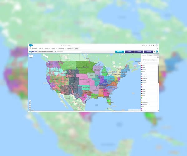
3. Balance Your Territories
Lopsided territories kill morale and revenue. We visualize the data so you carve up the map fairly, ensuring every rep has a shot at quota.
The toolkit
- Design instantly: Drag and drop boundaries on an interactive map. No complex coding
- Spot winners: Identify high-performing zones and coverage gaps immediately
- Align resources: Match your headcount to actual customer density
4. Control Your Territories
Markets move fast. If you can't adjust assignments in real-time based on new data, you leave revenue on the table.
The toolkit
- Assign instantly: Swap territories by geography, value, or industry in seconds
- Track live: Monitor performance trends as they happen. No lagging reports
- Optimize coverage: Use data to plug gaps and maximize reach immediately
5. Map Your True Reach
Radius circles lie, they don't account for roads or traffic. We visualize real-world accessibility so you know exactly which customers you can service.
The insights
- Measure drive time: See who is reachable in 15, 30, or 60 minutes
- Spot hotspots: Heat maps reveal high-density sales zones instantly, so you hunt where the revenue is
6. Get Instant Answers
Raw numbers are hard to read. We turn complex data into visual stories so you can spot trends and act fast.
The toolkit
- Customize: Build maps on the metrics that actually drive revenue. No fluff
- Visualize: Use interactive maps to identify patterns in seconds
5 Reasons to Choose eSpatial
- One platform -Stop juggling apps. We combine mapping, sales territory optimization and routing into one integrated suite.
- Zero learning curve - Our interface is built for speed. Anyone can create pro-level maps instantly, no coding required.
- Data You Trust - Decisions require accuracy. Our auto-sync tools ensure your maps always reflect real-time CRM data.
- Total customization - Don't settle for generic views. Tailor every data layer and color scheme to fit your specific goals.
- Real ROI - Maps are pretty; results are better. We help you optimize territories and routes to boost efficiency and revenue.
No credit card required
Flexible Pricing to Suit Every Business
Our team is here to help you every step of the way
What Our Customers Say
eSpatial is perfect for operations, RevOps, sales, and marketing. We designed it to be the easiest-to-use spatial analytics platform, which is why our users love it. The interactive map capabilities, powerful analysis tools, customization options, and other advanced features, make eSpacial the perfect fully integrated solution to create maps and optimize performance.
“We wanted to know for each of our plants. What is the plant's low-cost service area? What is the geographic region around that plant? And whether that plant is the most cost-effective option to ship concrete. We wanted to take advantage of that. We also wanted to know the most costly delivery areas in central Texas. And which of our customers are in those areas.”
“The first quick win for us was that eSpatial was so easy to use. After using so many other applications, eSpatial was the easiest for importing our data and identifying the fields and hierarchies that would deliver efficient alignments. At the end of the day, you are finalizing the sales territory in front of their eyes. It is much more real to the key stakeholders, which has been transformational for Thermo Fisher.”
“Sales data can be mapped in minutes. That has saved us countless numbers of hours. And we have eliminated steps from the design and approvals process leading to faster more efficient alignments in less time. The findings in our eSpatial visualizations are definitely going to inform 2022 strategy for the better. 100%, we're going to renew our eSpatial license.”
“We're always trying to improve our output and what we're putting in front of executive management teams and boards. We started looking around at different data visualization and mapping software programs and did a fair amount of due diligence on multiple companies. After vetting various platforms, eSpatial rose to the top of our list. I personally can say that we've loved it ever since.”
“I've been in this industry for 35 years, and to have a tool that I can pick up and use quickly just means the world to me. With eSpatial, I can create reports and make changes in 20 minutes, it's easy to log in and update things quickly. You wouldn't think in mapping software you would have someone so responsive in technical support. That was the prime reason I settled on eSpatial.”
“eSpatial has been an awesome tool for Starkey. From our territory planning; splitting territories, adjusting for local details, communicating and mocking up options. Then giving that updated detail to our sales team along with live access to CRM and trip planning. And then representing everything in a beautiful way that we love to use in presentations - it is truly a very impressive package.”
“eSpatial is an irreplaceable tool for our business, for example we are now able to run one of our key processes 32 times faster and have been able to double the number of customers we can visit in a given week by making better decisions. You can't control how much time you have in a given day, but you can control how it is used and eSpatial has certainly helped us significantly with that.”
Frequently Asked Questions
How Does CRM Maps Software Work?
CRM mapping tools turn static lists into dynamic maps by plugging directly into your CRM.
The process
- Connect: We integrate with your existing system to pull live data
- Visualize: We plot that data on customizable maps instantly
- Act: You spot trends and optimize territories based on geography, not guesses
Why Map Your CRM Data?
Visual context changes everything. You move from guessing to knowing by seeing exactly where your opportunities live.
The impact
- Optimize territories: Ensure fair coverage and max revenue
- Route smarter: Cut windshield time; increase face time
- Segment better: Target customers based on actual location
- Plan strategically: Spot market gaps and trends instantly
Can CRM Maps Software Help With Territory Management?
Absolutely! Unbalanced territories burn out reps and leave money on the table. We help you carve up the map fairly so everyone wins.
The fix
- Create instantly: Build and adjust territories in clicks, not day
- Balance workloads: Distribute accounts evenly to ensure fair quota attainment
- Optimize resources: Place your people exactly where the revenue opportunity sits
Can I Customize the Maps and Reports Generated by CRM Map Maker?
We give you full creative control to match your specific business goals.
Do I Need Technical Expertise?
Complex software gathers dust. We built eSpatial for business users, not developers, so you can launch without waiting on IT.
The reality
- Start instantly: Our intuitive design means there is no steep learning curve
- Self-serve: Upload, map, and analyze data yourself in minutes
- We help: Access comprehensive support resources if you ever get stuck
Can It Help With My Marketing Campaigns?
You visualize customer segments geographically so you spend ad dollars exactly where they convert.
The strategy
- Segment visually: See instantly where your specific personas live
- Spot targets: Identify high-density opportunity zones for events or ads
- Localize offers: Tailor your message to specific regions based on real data
Is It on Mobile?
Yes, your team can access critical data and insights on the go.