Distance measurement tool


The easy way to measure the distance between two or more points

Sign up for a free 14-day trial
Distance measurement tool
What is a distance measurement tool
Video transcript for What is a distance measurement tool

A distance measurement tool is a feature in mapping software that lets users measure the distance between 2 or more points on a map.

So, for example, I want to see what the distance is if I was travel to these 6 points. Just select my measure distance tool, click on the 6 points, create a polygon, and then the distance details, the drivetime and the area are shown below.


What is a distance measurement tool?

A distance measurement tool is a feature in mapping software that lets users measure the distance between two or more points on a map.

Typically, users can select points on the map, and the distance measurement tool calculates and displays the distance between those points. The measurements can be provided in different units, such as kilometers, miles, meters, or feet, depending on the user's preference or the specific requirements of the task.

What can it do for you?

Distance measurement tools are valuable for planning routes, assessing the length of boundaries, estimating travel distances, and conducting various spatial analyses. They enhance the functionality of mapping software, making it a versatile tool for operations, sales, sales operations and marketing professionals.

How do you use it?

To measure the distance between two points on the map, follow these steps:

Step 1

Select the point you wish to measure from.
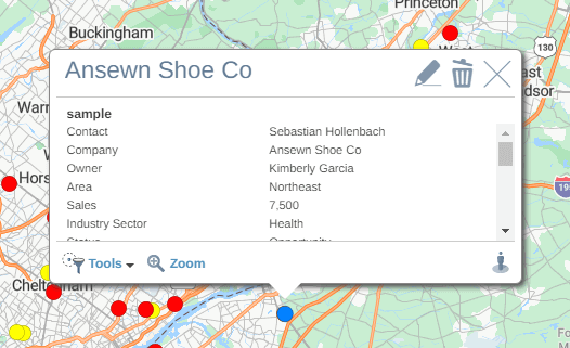
Point selected on a map

Step 2

Select the Tools option when the info pop-up appears.
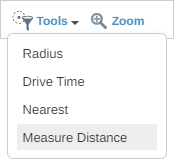
Tools dropdown

Step 3

Choose Measure Distance from the list.

Measure distance link

Step 4

The measure tool crosshair will then appear on the screen.
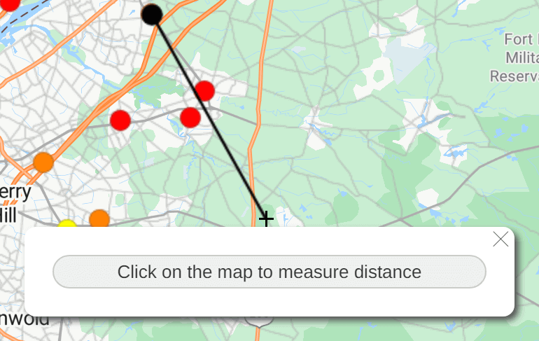
Distance measurement cursor on map

Step 5

Click anywhere on the map to measure the distance to that point. The distance pop-up will appear, showing the straight-line distance in miles, the driving distance in miles, and the estimated driving time.
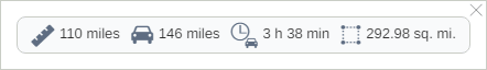
Distance measurement panel

Step 6

To add more points to your measurement calculation, continue clicking on your map. To edit the measure line, click and drag any of the nodes.

Step 7

To close the polygon, click on the starting point.

Step 8

Click the X on the distance pop-up to remove the measurement line or shape.

You appear to be offline at the moment, this notice will disappear once your device can connect to the internet again