Business mapping software reveals where your best opportunities are hiding. Instantly spot customer clusters, market gaps, and high-potential areas with location-based insights. With this clarity, you can target smarter, sell faster, and grow strategically.
Our Customers Love Mapping With eSpatial
Unlock Smarter Business Decisions With Mapping
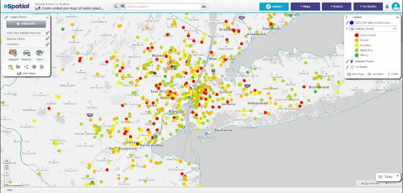
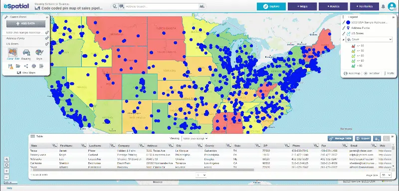
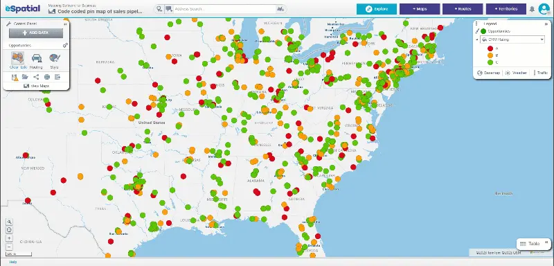
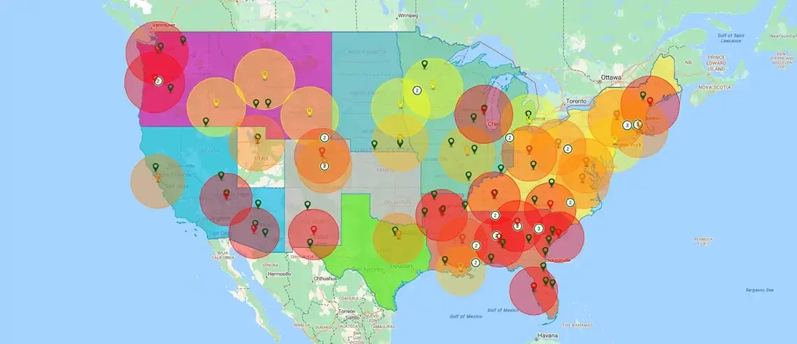
Mapping effectively bridges informational gaps, identifies bottlenecks, and calculates metrics to improve business processes. Business mapping software empowers organizations to uncover valuable insights by visualizing data from systems like Excel, CRM, and ERP. With improved visibility into operations, sales performance, and market potential, teams can identify inefficiencies, streamline processes, and plan smarter.
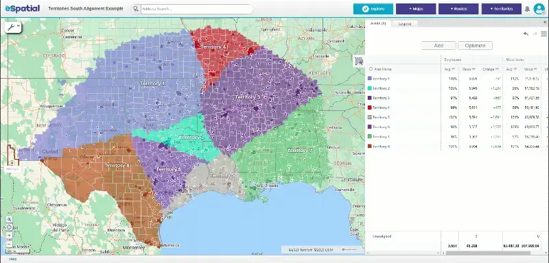
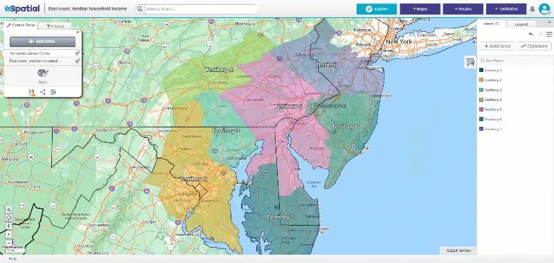
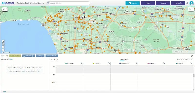
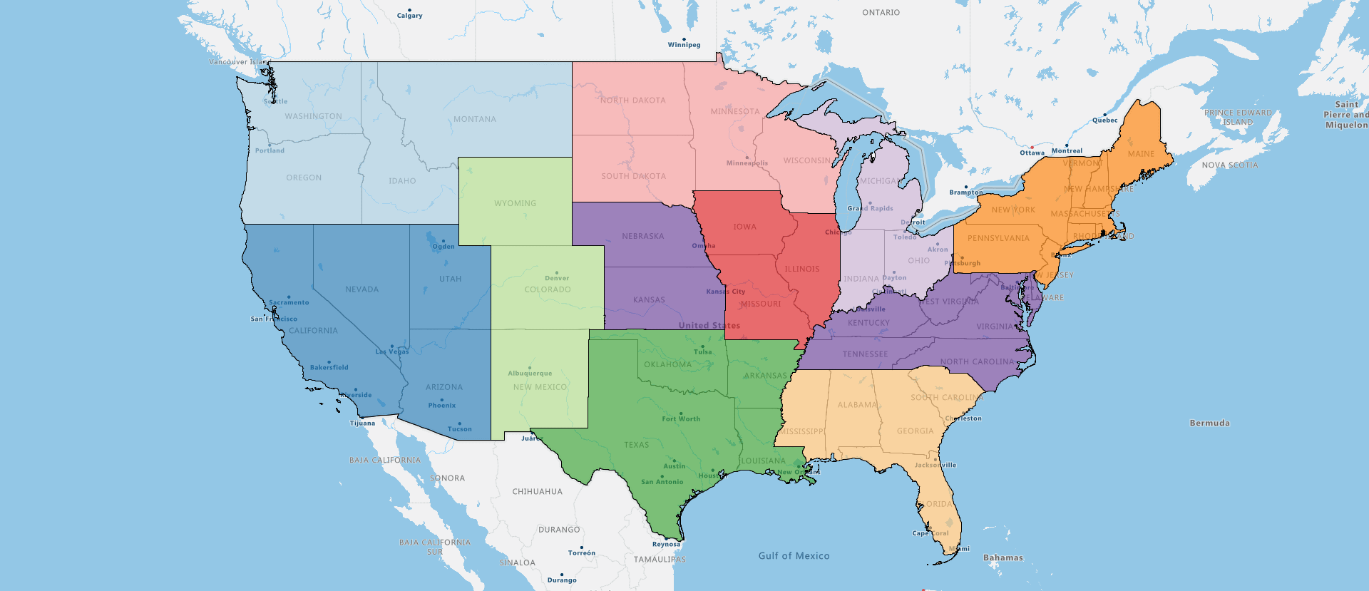
Plan your marketing campaigns more effectively and stay ahead of your competitors. With our mapping software, you can analyze your sales territories and performance and identify new expansion opportunities. This helps minimize wasted resources and leads to stronger decision-making across sales, logistics, and marketing, giving your business a powerful competitive edge.
Understand Your Market


Market Segmentation
Our mapping software lets you geographically visualize customer and prospect data on interactive maps, which helps identify natural groupings and spatial patterns for segmentation. The software also allows customers to be filtered and selected based on specific attributes to define and slice market segments.

Competitor Analysis
Maps visualize your competitors' strengths and weaknesses, helping you spot underserved areas with an opportunity to expand. Retailers can easily identify market gaps and opportunities by analyzing competitor locations and market coverage on maps. You can also track your competitors' new locations to stay ahead of strategic moves.
Optimize Sales and Territory Planning
With territory management from eSpatial, it's never been easier to build, balance, and optimize your territories to maximize performance and sales. Design geographic and accounts-based boundaries to perfect territories and compress project time by up to 92%. Merge, edit, and refine territories using weighted balances or workloads, and perform what-if scenarios to test and share alignments.


Location Analysis
Location analysis enables businesses to pinpoint ideal sites for maximizing exposure while minimizing competition. Companies can identify market gaps and opportunities by evaluating potential locations based on demographics and competition. Additionally, optimizing delivery routes through this analysis can significantly save time and fuel costs.


Customer Targeting
Our territory planning and geo-fencing tools allow businesses to target customers by location. These location-based insights also help identify geographical patterns and customer preferences. This enables companies to serve their target audience better.
Improve Operations and Team Efficiency
Mapping software for a business enhances team performance by aligning resources with demand in each area. Better visibility into field activity helps managers assign tasks more effectively and reduce overlap. This leads to stronger coordination, faster response times, and better service delivery.


Increased Operational Efficiency
Route optimization tools help reduce travel times and mileage, lowering fuel costs and fleet maintenance needs. Strategic territory design balances workloads and reduces inefficiencies across teams. It results in lower operating costs and more consistent performance across the organization.


Streamlined Logistics and Supply Chain Management
Our route optimization reduces transportation costs by minimizing distances, times, and fuel usage for delivery, field sales, and service teams. Mapping allows visualization of routes to identify redundancies and opportunities for optimization. It results in improved operational efficiency and reduced overhead costs.
Communicate Insights Visually
Visual maps turn complex data into clear, compelling stories. They make it easier to share insights across teams, executives, and stakeholders. With interactive visuals, everyone can quickly grasp trends, spot opportunities, and take action.
Visual Communication With Interactive Maps
Maps are the perfect way to communicate with internal teams, stakeholders, and partners. Visual representations make complex geographic data more accessible and easier to understand than traditional reports or spreadsheets. With mapping software for businesses, retailers can use maps to visually present data, strategies, and insights, which helps to facilitate better collaboration and decision-making:
- Staff
- Customers
- Key assets
- Office locations
- Distribution centers
4 Reasons Businesses Choose eSpatial
-
Optimized territories
and routesStreamline territory management and route planning to reduce inefficiencies and boost performance
-
Guided onboarding
and supportBest-in-class one-on-one onboarding and support ensure successful implementation
-
Powerful Visual
InsightsUsers can make more confident data-driven decisions quickly with visual-spatial insights
-
Easy to learn
and useThe software is intuitive and easy to learn with a simple learning curve—no GIS experience needed
How eSpatial's Business
Map Software Works
eSpatial business map software combines your location data with business information to create visual maps that help you make better decisions. The platform shows you where your customers, sales, and operations are happening on an easy-to-read map. Getting started is simple—just follow the steps below:
Step 1
Sign in / Sign up
If you already have an account with us, just sign in to your eSpatial account using your credentials. Otherwise, sign up for free on our website.
Step 2
Upload Your Data
Upload your company's data, such as customer locations and sales figures.
Step 3
Map Your Data
Transform uploaded data into interactive maps with varying symbols, colors, and layers.
Step 4
Analyze on Maps
Use tools like heat maps, route planning, and territory design to visualize insights from mapped data.
Step 5
Share Insights
Collaborate by sharing maps internally or externally. Export maps as images for presentations.
Business Data Mapping
for Every Industry
Business data mapping software applications vary by industry based on specific needs. For businesses involved in delivery and transportation, routing optimization is often the primary focus, whereas consumer-facing businesses like retail stores, restaurants, and service companies benefit most from location analysis. Businesses with sales representatives in the field use territory and account mapping to maximize coverage and efficiency.
eSpatial helps every team turn complex data into clear, actionable insight—no matter the industry.

Financial Services
Data mapping helps aggregate and reconcile data from multiple sources to ensure accurate and consistent financial reports. Consolidating and translating risk-related data from different systems through mapping allows risk assessment and management, providing the necessary protection for your company. Optimize your risk management strategies with our mapping software for financial services.

Healthcare
Data mapping in the healthcare industry is critical as it integrates and analyzes patient data from various sources, making it accessible to authorized providers. Mapping addresses and visit schedules help optimize staff and transport routes for home visits and mobile services. Ensure your healthcare facilities maximize efficiency and patient care with our routing, territory, and mapping software for healthcare services.

Manufacturing
Mapping builds a visual map of current sales coverage and potential business opportunities to maximize benefits and efficiencies for sales teams. By identifying manufacturing "hot spots'' where specialized industries cluster, mapping helps focus resources and target the right market areas. You can also optimize logistics and improve productivity with our mapping software for manufacturers.

Real Estate
Maps analyze demographic and market data to identify optimal locations for new developments, which helps decide site relocations. Realtors can visualize and optimize coverage areas based on property or client locations. Interactive maps also enhance communications between realtors and customers, which increases conversion rates. Let our mapping software for real estate organizations analyze market trends so you can make informed decisions for your business.

Retailers
Business data maps analyze customer locations, demographics, and competition to help identify prime store locations. Route planning and workload balancing also improve delivery logistics. Through the spatial lens, retailers can effectively analyze competitor locations and coverage. Get a competitive edge in the retail industry with our mapping software.

Software and Tech
Mapping software helps tech companies optimize sales planning, infrastructure management, and field operations through visual location insights. Maps provide spatial context for competitive analyses, new market identification, and customer success coverage. Our mapping software for software and tech companies also helps improve staff retention by assigning sales reps and field staff to areas closest to their homes.

Construction
In construction companies, mapping software is the building block for optimizing operations. By layering many data types on maps, companies can visualize potential locations and improve planning, resource allocation, and client communications. Improve risk management by analyzing geographic data to identify potential risks at construction sites with mapping software for the construction industry.

Wholesalers and Distributors
Mapping tools allow wholesalers and distributors to analyze delivery performance, identify trends, and make data-driven decisions to improve operations. Optimizing routes and efficiency directly helps reduce fuel costs, labor, and vehicle maintenance through interactive maps. Maximize your teams’ effectiveness by optimizing sales and service territories with our routing, territory, and mapping software for wholesalers and distributors.