• Data visualization

How to Map Employee Locations Fast

Liam Costello
  • Published: April 10, 2023
  • Updated: November 7, 2025
  • Author: Liam Costello
  • Reading time: 10 mins

Quick answer

Visualising where your employees live and work is a game-changer for smarter planning, cost savings, and team cohesion.

To map employee locations, you collect address data in a spreadsheet and upload it to a mapping tool. This lets you instantly visualise workforce distribution, identify clusters or gaps, and make smarter decisions on office planning, territory assignments, and team logistics.


Why Map Employee Locations


Mapping your workforce is a core strategic tool. It's the fastest way to stop guessing and start seeing where your people and customers actually are with business mapping solutions

Visualising your team's locations helps you:

  • Optimise sales, service, or ops territories.

  • Find the best location for a new office or depot.

  • Cut travel time, lower costs, and plan smarter.

Pin map, with a radius overlay

What You Gain by Mapping

  • Visualise Distribution: Instantly see workforce clusters, coverage gaps, and remote work patterns from a simple spreadsheet.

  • Support Decisions: Optimise territories to cut overlap, plan new depots near your team, and lower operational costs.

  • Boost Safety & Cohesion: Support work-life balance with smarter schedules and locate teams quickly during an emergency.

Learn more about spatial analysis for planning and how it can ensure equal distribution of workloads.

Drive time analysis map of Washington

Support Business Decisions

Mapping employee locations unlocks the data you need for strategic decision-making.

WHAT YOU CAN DO:

  • Optimise territories to reduce sales overlap and improve service coverage.

  • Plan new offices or depots closer to where employees live for better resource efficiency.

  • Cut travel time, lower operational costs, and improve service delivery.

Territories by value

Enhance Team Cohesion and Safety

Knowing where your employees are based is essential for wellbeing and rapid coordination.

  • Create smarter schedules that lower travel time and support a healthier work-life balance.

  • Locate teams quickly during unexpected events, ensuring faster, safer coordination.

  • Build a connected workforce by understanding where your people are and how best to support them.

What You Need for Mapping


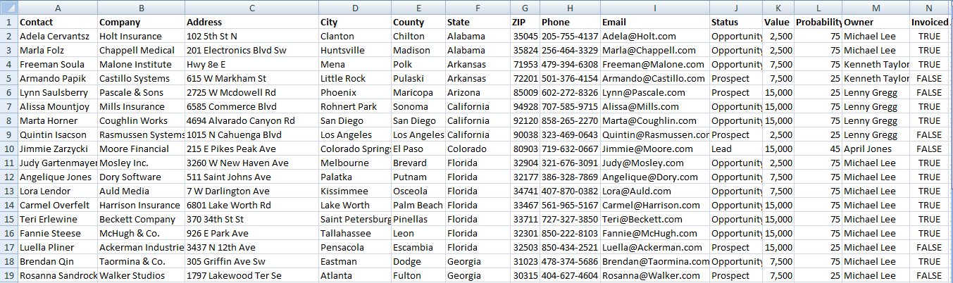
You only need one thing to start: a structured spreadsheet with reliable address data (home and office).

RECOMMENDED SETUP:

  • Tab 1: Employee home addresses.

  • Tab 2: Employee work locations.

PRO-TIP: To use a single spreadsheet, just add one column to show if the location is "Work" or "Home."

Recommended Fields for Mapping

  • Employee name
  • Employee email address
  • Employee contact phone number
  • Employee department
  • Employee job title
  • Employee type (office, hybrid, remote) is optional
  • Home address, including street details and ZIP code
  • State

A 5-step Guide to Mapping
Employee Locations


You can turn a simple spreadsheet into a clear, interactive map in minutes. This is the fastest way to plan office space, manage remote teams, or optimise regional coverage.

Step 1

Step 1: Collect and Clean Your Data

Gather your employee location data in a single spreadsheet.

The data must be clean and consistent. This is essential to ensure you can accurately geocode and map every location.

MINIMUM FIELDS:

  • Name

  • Address

  • City

  • Postcode

  • Department or Team

Spreadsheet data example

Step 2

Step 2: Choose the Right Mapping Tool

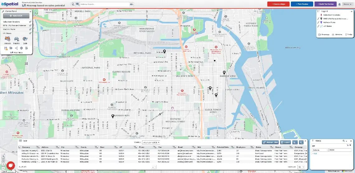
A strong mapping tool (like eSpatial's mapping software for teams ) will include features tailored for workforce planning, such as territory management software, and dynamic filtering.

MATCH YOUR MAP TO YOUR GOAL:

  • Pin maps: Visualise individual employee locations.

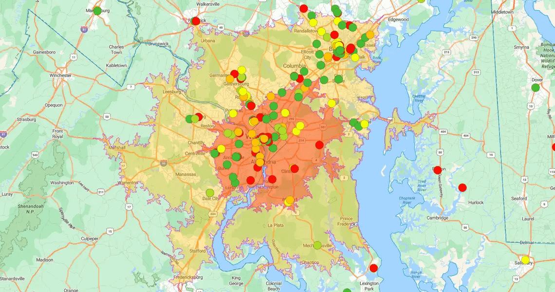
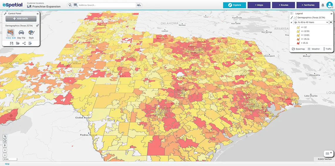
  • Heat maps: Identify employee concentration and density.

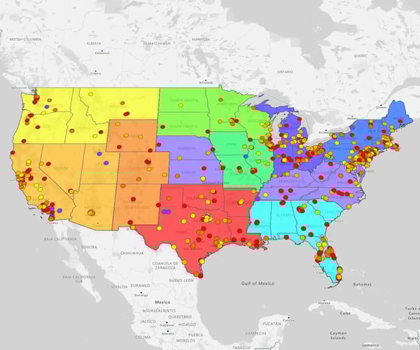
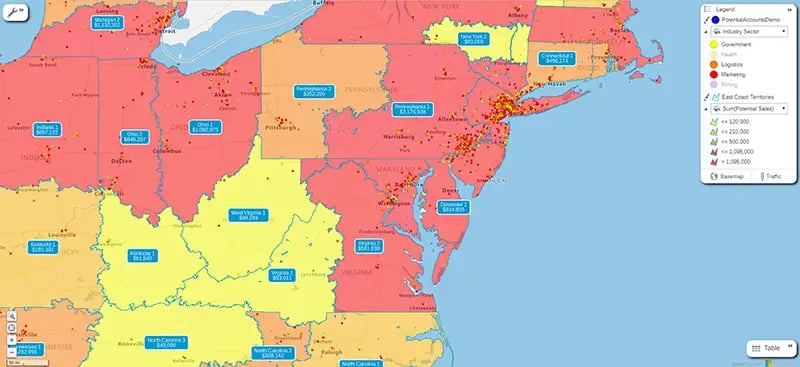
  • Territory maps: Assign employees to regions or manage field teams.

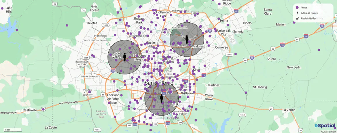
  • Radius maps: Analyse travel-time and proximity.

  • Filter/Layer tools: Sort and segment your map by criteria.

Step 3

Step 3: Upload Data and Customise Pins

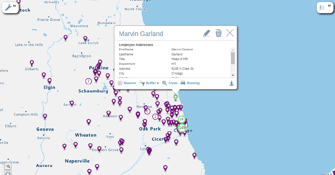
Import your spreadsheet to geocode your employee locations.

WHY IT MATTERS: You must customise your pins—by color, shape, or category (like role, region, or department)—to make your map instantly understandable.

Employee location pin map

Step 4

Step 4: Apply Filters and Analyse Patterns

This is where you find your opportunities. The map's visualisations will instantly reveal clustering, coverage gaps, or overlap, helping you spot logistical and strategic wins.

HOW IT WORKS:

  • Filter on any field in your sheet to sort or hone your map.

  • Focus on subgroups (e.g., "service teams") to understand their specific spread.

  • Click any pin on the map to see that employee's full details.

Read more about filtering.

How to map employee locations map ZIPs
A map of Milwaukee showing Zips

Step 5

Step 5: Use Your Insights for Strategic Decisions

This is the payoff. You can now turn your map into a strategic tool to support data-driven planning.

KEY ACTIONS:

  • Identify ideal locations for new offices.

  • Rebalance sales or service territories.

  • Reduce travel time for your field teams.

  • Support hybrid work and office planning decisions.

  • Share your map with HR, ops, or leadership to get alignment.

Tools to Map Employee Locations


From dedicated mapping platforms, like eSpatial, to GPS tracking apps and simple DIY options, there’s a solution for every business need and budget. Here are some of the most common tools companies use to visualize and manage their employee locations effectively:

Texas heat map

Mapping Platforms (maptive, eSpatial)

Dedicated employee location mapping platforms like eSpatial and Maptive make it simple to visualize and analyze employee locations on interactive maps. These tools let you:

  • Import data quickly from spreadsheets or CRMs to see your workforce distribution in seconds
  • Build dynamic maps that update as your data changes, keeping your view current and accurate
  • Create territory maps, heat maps, and proximity analyses to support strategic planning and resource allocation

1. Real-Time GPS Tracking (Field Teams)

What it it: Apps (like Hubstaff, QuickBooks Time, or Hellotracks) that provide real-time visibility of mobile and field staff.

Use it to:

    • Track routes and time on-site to cut mileage.

    • Dispatch the nearest employee for urgent jobs.

    • Boost accountability and improve customer service.

2. Office Mapping & Desk Booking (Office Teams)

What it is: Tools (like Robin, Envoy, or OfficeSpace) that create digital floor plans for office-based or hybrid teams.

Use it to:

    • Enable "hot-desking" by letting staff reserve desks or meeting rooms.

    • Help employees quickly find colleagues.

    • Track desk occupancy to improve space utilisation.


3. DIY Spreadsheets (Basic Visuals)

What it is: Using tools like Excel or Google Sheets to plot employee addresses for a simple, static map.

  • Use it to:

    • Visualise basic workforce distribution.

    • Spot obvious gaps or clusters in your team.

  • The catch: This is a starting point. As your data grows, these tools become unwieldy. You'll quickly need a dedicated GIS platform, like eSpatial, to map data effectively.

The bottom line: Whether you start with a simple spreadsheet or move to a dedicated platform, visualising your workforce makes complex decisions faster and easier.

Key Takeaways on Mapping
Employee Locations


Visualising your workforce is a powerful way to make smarter, faster decisions.

  • It helps you plan more effectively, reduce costs, and keep your teams connected and safe.

  • Whether you start small with a spreadsheet or use a dedicated platform like eSpatial, the value is immediate.

  • With eSpatial's pricing plans, it's an investment that quickly pays off.

Plus, with eSpatial's pricing plans, it's an investment that quickly pays off.

Frequently Asked Questions


Why is a Map Better Than My Current Spreadsheets and Dashboards?

Because static lists and dashboards can't answer the crucial "why of where."

In a world with more distributed teams than ever, simply knowing who your employees are is not enough. Mapping transforms your scattered data into a single, interactive view.

This visual context allows you to:

  • See talent clusters instantly.

  • Identify geographic skill gaps.

  • Understand your competitive landscape in seconds.

The bottom line: You stop just reading a list of addresses and start understanding your organisational footprint. This lets you make proactive decisions about hiring, resource allocation, and team collaboration.


How Can Mapping Help Me Manage My Remote or Hybrid Team?

By mapping your team, you instantly visualize your entire workforce footprint.

Managing a distributed team from a spreadsheet is like navigating without a map. This visual clarity is key to building an efficient, connected, and well-supported team.

You can immediately:

  • Optimize travel: Use drive-time analysis to plan efficient sales or service meetups, cutting travel costs by up to 30%.

  • Identify regional hubs: Visually answer the strategic question, "Where should we establish our next hub?"

  • Ensure equitable support: See exactly where every employee is located, not just those near an office.

How Can I Find the Best Talent Pools in a New Territory?

Guesswork is a risky and expensive way to build a team.

eSpatial helps you build a strategic hiring plan by mapping multiple data layers at once—such as candidate density, competitor locations, and customer clusters—to visually pinpoint exactly where to focus your recruitment efforts.

Instead of starting with a blank map, you can overlay critical data to find your ideal hiring zones:

  • Visualise candidate data from your ATS.

  • Map all competitor offices to understand the talent landscape.

  • Identify where your top-performing reps live to model success.

The bottom line: This transforms your hiring plan from a reactive guess into a proactive, data-driven strategy, ensuring you invest resources in the locations with the highest potential.

How Do I Find the Best Locations for Recruitment Events?

You can find the best recruitment event locations by using heatmaps to instantly visualize "hotspots" where your ideal candidates are most concentrated, ensuring maximum ROI on your event spend.

Choosing a city for a recruitment fair is easy; choosing the right neighbourhood is strategic.

  • How it works: Upload your lists of past applicants, LinkedIn prospects, or industry-specific talent data.

  • The result: A heatmap immediately reveals the geographic clusters of your target audience.

This allows you to select a venue with data-backed confidence, moving beyond assumptions and placing your event right in the heart of your future talent pool, which is critical for making every recruiting dollar count.

My Team Aren't Data Analysts. is Your Tool Too Complex for Them?

This is a valid and common concern.

eSpatial is designed specifically for business users, not data scientists. Your team's expertise is in talent strategy, not software engineering—our platform was built to empower that expertise, not create a technical roadblock.

We ensure adoption with two simple steps:

  • Simple workflows: We turn complex tasks—like identifying skill gaps or planning for succession—into simple, visual workflows.

  • Day-one support: Our dedicated customer success team partners with you to ensure your team feels confident and gets tangible value from day one.

The bottom line: Your team can focus on what they do best: building a great workforce.

How Does eSpatial Integrate? Will This Require a Lot of It Help?

eSpatial makes integration simple by design, minimising IT dependency.

No one wants an implementation that drains IT resources or takes months to deliver value. We believe you should be able to get answers from your data yourself, without waiting in line for technical support.

You can get mapping in minutes, in two ways:

  • Direct Connections: Link seamlessly to systems you already use, like your CRM (e.g., Salesforce).

  • Drag-and-Drop: Simply upload an Excel file or spreadsheet.

This allows you to blend and visualize data from all your sources, turning a process that used to take weeks into something you can do before your next meeting.

What's the ROI of Mapping My Employees?

Mapping your employees provides a clear ROI by enabling data-driven hiring, cutting travel costs, and aligning talent with revenue opportunities.

We understand that any new tool needs to deliver a clear business case. Mapping your talent provides ROI in three key ways:

  • 1. Better Hires, Faster: Strategic recruitment in talent hotspots leads to faster, better hires.

  • 2. Lower Costs: Optimize territories and travel routes to directly reduce fuel and time costs.

  • 3. Higher Revenue: Align your employee locations with customer data. This ensures your best people are focused on the biggest opportunities, directly contributing to revenue growth and preventing top-performer burnout.

How Does a Map Help Me Get Faster Buy-in From Leadership?

Because a map is a universal language. It transforms complex data into a clear, visual story that leadership can understand instantly.

It is a common challenge to make data compelling for an executive audience.

  • A spreadsheet showing headcount by state is just data.

  • A heatmap showing talent gaps and competitor saturation is a strategic conversation starter.

You move the discussion from "What does this mean?" to "What's our plan?" This visual clarity allows you to present an undeniable case for your recommendations and secure the resources you need.

If you need help, talk to a mapping expert or read one of our mapping software guides.

Ready to Map Your Employee Locations?

Map them now in your free trial

You appear to be offline at the moment, this notice will disappear once your device can connect to the internet again