Our Customers Love Mapping With eSpatial
Strategic Territory Solutions
-
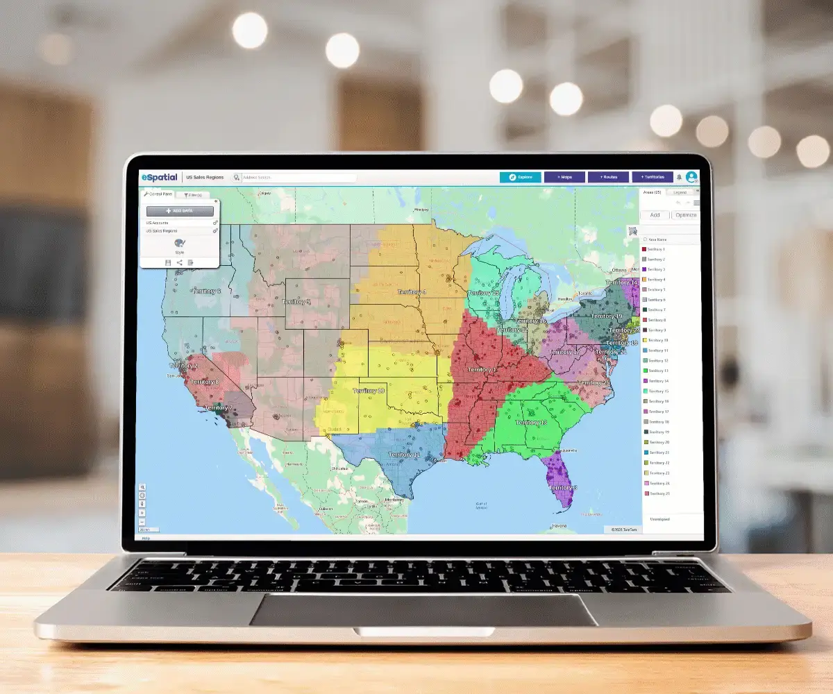
 Sales Territory Design
Move beyond basic boundaries. Use data-driven insights to build geographic, account-based, or hybrid models that align your sales team with maximum market potential. Turn territory design into a competitive advantage that boosts revenue and rep retention.
-
 Optimization & Balancing
Shift from "equal" to "equitable" territories. Use workload-based optimization to prevent rep burnout and eliminate lost revenue from unserviced accounts. Balance hundreds of territories in minutes to ensure every rep has a fair path to quota.
-
 Growth & Realignment
Markets evolve, your maps should too. Master active territory management by responding to personnel shifts and performance outliers in real-time. Protect your revenue from "territory drift" and scale your footprint with agile, data-backed realignment.
How Does eSpatial Eliminate
The Hassle of Manual Planning?

For Sales Ops leaders, geography is often a hidden dimension trapped in disconnected data. eSpatial moves you from wrestling with data to a state of high-velocity insight. Our software honors your expertise by putting the map back at the center of the strategy.
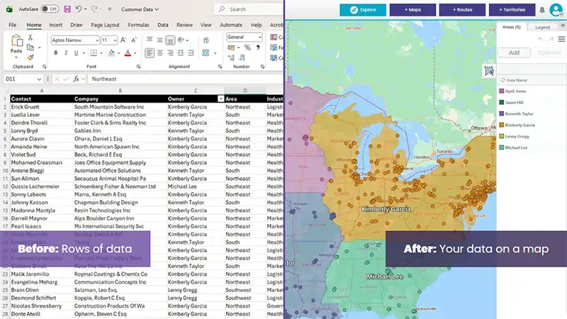
Proximity-Based Logic: Use visual proximity rules and ZIP code alignments to stop the manual "pen and paper" guesswork.
Salesforce Native Sync: Eliminate the data gap with a dedicated Salesforce Connector that keeps your design and execution in a single, seamless loop.
Revenue Optimisation Fuel Your Sales
Pipeline and Boost Productivity

1. Optimise Resources, Maximize Revenue
Optimised sales and service territories directly translate to higher ROI and improved customer service levels.
Stop leaving money on the table. A territory management system ensures efficient resource deployment by eliminating under-served or over-served areas.
The Payoff
Preventing resource waste directly increases sales while simultaneously reducing operational costs.

2. Kill Territory Overlap
Blurred territory boundaries drive up service costs, confuse customer relationships, and frustrate team members.
When multiple teams call on the same customers, it creates unnecessary conflict, damaging morale and wasting resources.
Territory management software excels in these scenarios. All stakeholders instantly see their areas of responsibility on a map, eliminating guesswork and conflict.

3. Sharper Focus, Higher Confidence
Clearly defined ownership allows reps to focus entirely on delivering results, not on internal confusion.
Clear roles support stronger planning, accelerated pipeline development, and immediate accountability.
-
Reps are immediately more motivated and confident when roles are clear
-
Accountability is visible, linking effort directly to performance, not luck
-
Team time shifts from discussing who owns an account to how to close it

4. Accelerated Onboarding
New hires ramp up faster with ready-to-go, clearly defined territories, shortening onboarding time.
Stop wasting training time. Reps can focus on engaging prospects and customers without delay, driving early performance and faster revenue capture.
Do This
Give new hires immediate clarity on their focus.
Not That
Letting new reps lose weeks figuring out their patch.

5. Slash Customer Response Times
Optimized territories dramatically improve customer response times, elevating your service quality immediately.
Customers demand speed. Defined, efficient coverage means the closest rep gets the call or visit quickly, meeting service-level agreements with ease.
The Result
-
Boost Confidence: Fast service builds client trust and loyalty
-
Cut Delays: No time is lost figuring out who is responsible for the client
-
Win Loyalty: Quicker fixes and follow-ups drive repeat business

6. Find Your Next Revenue Stream
The software provides data-driven insights that help you continuously identify and capture new revenue opportunities.
Stop guessing where the next deal is. Territory management instantly turns raw data into strategic actions to penetrate and dominate high-growth markets.
5 strategic Wins
-
Spot growth: Instantly highlight underserved and high-growth areas
-
Optimize: Dynamically adjust territories based on real-time market demand
-
Analyze: Conduct fast, in-depth territory analysis across all metrics
-
Expand: Pinpoint cross-sell and upsell potential within existing markets
-
Test: Safely deploy new sales strategies in targeted regions
Trusted by Businesses Globally
“We wanted to know for each of our plants. What is the plant's low-cost service area? What is the geographic region around that plant? And whether that plant is the most cost-effective option to ship concrete. We wanted to take advantage of that. We also wanted to know the most costly delivery areas in central Texas. And which of our customers are in those areas.”
“The first quick win for us was that eSpatial was so easy to use. After using so many other applications, eSpatial was the easiest for importing our data and identifying the fields and hierarchies that would deliver efficient alignments. At the end of the day, you are finalizing the sales territory in front of their eyes. It is much more real to the key stakeholders, which has been transformational for Thermo Fisher.”
“Sales data can be mapped in minutes. That has saved us countless numbers of hours. And we have eliminated steps from the design and approvals process leading to faster more efficient alignments in less time. The findings in our eSpatial visualizations are definitely going to inform 2022 strategy for the better. 100%, we're going to renew our eSpatial license.”
“We're always trying to improve our output and what we're putting in front of executive management teams and boards. We started looking around at different data visualization and mapping software programs and did a fair amount of due diligence on multiple companies. After vetting various platforms, eSpatial rose to the top of our list. I personally can say that we've loved it ever since.”
“I've been in this industry for 35 years, and to have a tool that I can pick up and use quickly just means the world to me. With eSpatial, I can create reports and make changes in 20 minutes, it's easy to log in and update things quickly. You wouldn't think in mapping software you would have someone so responsive in technical support. That was the prime reason I settled on eSpatial.”
“eSpatial has been an awesome tool for Starkey. From our territory planning; splitting territories, adjusting for local details, communicating and mocking up options. Then giving that updated detail to our sales team along with live access to CRM and trip planning. And then representing everything in a beautiful way that we love to use in presentations - it is truly a very impressive package.”
“eSpatial is an irreplaceable tool for our business, for example we are now able to run one of our key processes 32 times faster and have been able to double the number of customers we can visit in a given week by making better decisions. You can't control how much time you have in a given day, but you can control how it is used and eSpatial has certainly helped us significantly with that.”
Expert Backup on Demand

Don't map alone. You know your data; we know geography. When projects stall, our GIS experts step in to clear the path. Standard support can't solve spatial problems. You need dedicated mapping pros to handle complex data integration and design hurdles fast.
The Support
- Real expertise: Direct access to certified GIS specialists, not scripts
- Always on: We assist from day-one onboarding through to advanced analysis