

Quick answer
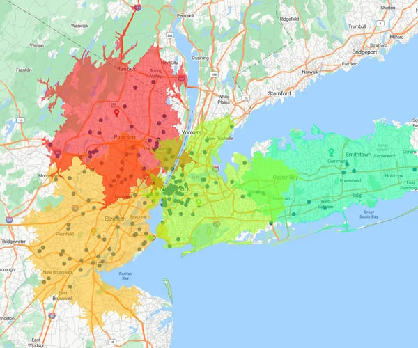
When urban service centers sit overwhelmed while neighboring regional facilities operate under capacity, operations leads are forced into expensive workarounds like flatbed trailer transfers to haul heavy machinery. Static spreadsheet boundaries hide these friction points until customer SLAs slip and travel costs surge.
Why Do Traditional Field Service Dispatch Models Create Inter-Site Waste and Burnout?
Traditional field service dispatch models create inter-site waste and burnout because static ZIP code boundaries and manual spreadsheets ignore facility backlog, technician drive times, and real-time skill sets. This causes overlapping service territories, excessive windshield time, and expensive inter-facility equipment hauling.
Managing field technicians and service hubs across multi-site manufacturing networks requires balancing unpredictable service requests with fixed facility capacity. When dispatchers manage these networks using flat spreadsheets or rigid ZIP code lookup tables, critical spatial bottlenecks emerge:
Capacity Imbalances
Urban service centers become overwhelmed with work orders while surrounding rural facilities sit underutilized
Inter-Facility Transport Overhead
To relieve backlogs, service operations resort to hauling heavy equipment, machinery, or components on flatbed trailers between facilities
Technician Windshield Time
Service reps waste up to 30% of their working hours navigating inefficient travel routes across overlapping territories
Relying on spreadsheets hides these operational friction points. Modern Enterprise mapping software replaces flat rows of addresses with interactive drive-time boundaries and weighted workload balancing, enabling field service leaders to align territories in hours rather than weeks.
What Is Drive-Time Workload
Balancing in Field Service Operations?
Drive-time workload balancing is a spatial optimization strategy that aligns technician coverage and facility boundaries using real-world travel corridors and workload indices. It replaces rigid mileage radiuses with exact drive times to equalize dispatch volume across multi-site service networks.
When service operations teams draw coverage boundaries using straight-line mileage radiuses (e.g., "every account within 20 miles"), they fail to account for real-world travel friction. A 20-mile drive across a congested metro area can take 90 minutes, while a 35-mile drive down an open highway takes only 30.
|
Boundary Approach |
Operational Assumptions |
Real-World Impact |
Workload Result |
|---|---|---|---|
|
Static 20-Mile Radius Ring |
Assumes equal travel time in all directions. |
Ignores traffic congestion, bridges, and speed limits. |
Unbalanced workloads and excessive windshield time. |
|
eSpatial 30-Minute Drive-Time |
Shapes boundaries around actual highway corridors. |
Accounts for travel friction and road networks. |
Equalized technician workloads and zero wasted drive time. |
Field service managers deploy easy-to-use territory mapping tools to build service boundaries using actual drive-time radiuses combined with custom workload metrics:
Workload Indexing
Assign custom weights to accounts based on equipment complexity, machine counts, or active service contract tiers
Drive-Time Buffers
Generate 30, 45, or 60-minute travel boundaries around service centers to establish realistic service-level agreements (SLAs)
Scenario Testing
Perform "what-if" boundary adjustments to reallocate accounts between neighboring technicians before committing changes to the field
Weighted Service Territory Balancing
Select
Select technician territories and apply a custom workload index (e.g., active machine maintenance contracts).
Run
Run automated alignment algorithms to equalize work orders across neighboring service hubs.
Tweak
Perform quick manual drag-and-drop tweaks to account for local field knowledge before sharing alignments.
How Did a Repair Network Achieve
$0 Inter-Site Transport Waste?
A National Car Repair Network achieved $0 inter-site trailer transport costs across 20+ facilities by implementing eSpatial's drive-time territory balancing.
Replacing manual spreadsheet mapping with dynamic service boundaries equalized facility workloads and reduced realignment design cycles from weeks down to hours.
|
Operational Metric |
Spreadsheet Dispatch Baseline |
eSpatial Drive-Time Alignment |
|---|---|---|
|
Primary Operational Bottleneck |
Backlogged sites forcing costly flatbed trailer transfers. |
Balanced incoming service requests across surrounding sites. |
|
Inter-Site Transport Waste |
Recurring flatbed trailer hauling expenses between hubs. |
$0 Inter-Site Flatbed Transport Costs Achieved. |
|
Realignment Cycle Duration |
Weeks of manual spreadsheet work. |
Realignment cycles compressed from weeks to hours. |
What Is the 4-Step Framework for
Optimizing Field Service Territories?
The 4-Step Framework structures field service territory optimization into four sequential phases: Network Visualization, Skill & Account Mapping, Drive-Time Alignment, and Route Execution. This framework eliminates dispatch bottlenecks, removes inter-site waste, and maximizes daily technician productivity.
Establishing efficient service territories requires connecting high-level operational strategy directly to daily field execution. Following a structured four-phase workflow ensures field service leaders systematically eliminate spatial friction across multi-site networks:
|
Phase |
Operational Focus |
Platform Capability |
Primary Metric Tracked |
|---|---|---|---|
|
1. Network Visualization |
Map service centers, customer assets, and active technicians. |
Multi-layer data stacking and visual heatmaps. |
Facility coverage visibility; service gap identification. |
|
2. Skill & Account Mapping |
Assign account tiers and required technician skill sets via Excel/CSV or Salesforce. |
Color-coded pin filtering and account categorization. |
Skill-to-job match rate; right-person allocation. |
|
3. Drive-Time Alignment |
Create realistic service zones around facilities using drive-time buffers. |
Plan drive-time boundaries and radius buffers. |
Inter-site transport elimination ($0 trailer waste). |
|
4. Route Execution |
Plan multi-stop service routes and assign emergency dispatches on the go. |
Multi-stop route optimization and mobile re-optimization. |
30% reduction in windshield time; increased daily stop velocity. |
By progressing through this framework, service operations leads shift from reactive fire-fighting to proactive network management. Operations teams gain clear visibility into coverage gaps while giving field reps achievable, balanced daily schedules.
How Do Nearest Neighbor Search & Route Optimization Streamline Dispatch?
Nearest neighbor search and multi-stop route optimization streamline dispatch by instantly identifying the closest qualified technician for emergency requests and sequencing daily service stops. Technicians can re-optimize routes on mobile devices to cut windshield time by up to 30%.
When an urgent service ticket or machine breakdown occurs, dispatchers cannot afford to search through spreadsheets to find an available technician. eSpatial's Nearest Neighbor tool allows dispatchers to click any point on an interactive map and instantly identify the closest technician or service center with the required certification. Once jobs are assigned, eSpatial's multi-stop route planning automatically sequences field visits into logical travel corridors:
- Practical Advance Route Planning: Generate optimal multi-day travel schedules to maximize client-facing service time.
- Mobile Re-Optimization: Field service reps can re-sequence their daily stops on mobile devices while traveling to adapt to cancellations or urgent priority requests.
- Fleet Wear Reduction & Higher Stop Velocity: Cutting windshield time by up to 30% significantly reduces fuel costs, minimizes vehicle maintenance overhead, and adds 2 to 3 completed work orders per technician daily.
How Does eSpatial Fit Into Your
Field Service Tech Stack?
eSpatial fits into field service workflows via , bi-directional Salesforce CRM synchronization and easy Excel or CSV file uploads. Under ISO-27001 security standards, dispatch teams balance service boundaries and manage field routes without needing complex GIS software.
Field service organizations need agile tools that complement their existing operations without adding software bloat. eSpatial offers a lightweight, secure bridge between customer data and field execution:
Salesforce
CRM Sync
Keep service account status, technician assignments, and territory boundaries synchronized continuously between eSpatial and Salesforce
Simple Excel
& CSV Imports
Quickly upload supplementary datasets—such as equipment locations, asset histories, or technician skill rosters—from standard spreadsheets in seconds
ISO-27001
Certified Security
Enterprise-grade security compliance ensures sensitive customer asset records and service network boundaries remain protected
Intuitive User
Experience
Require zero GIS experience, allowing dispatchers and operations leads to design, tweak, and share interactive maps instantly
Stop Managing Field Service on Spreadsheets
Transform your multi-site dispatch operations with eSpatial's interactive drive-time territory balancing. Stop losing hours to overlapping boundaries, inefficient routing, and costly inter-facility transport. See how easy it is to visualize your network, instantly assign the closest qualified technicians, and achieve balanced workloads across your entire service area.
No credit card required
Frequently Asked Questions
The Repair Network replaced static spreadsheet mapping with eSpatial’s 30-minute drive-time buffers and weighted workload balancing across 23 facilities. Equalizing service capacity across surrounding sites eliminated equipment backlogs and completely wiped out inter-site flatbed trailer hauling costs.
Nearest Neighbor allows dispatchers to click any location or account pin on an interactive map and instantly identify the closest technician, service center, or asset. This speeds up job assignment and emergency service dispatches.
Service reps and dispatchers can plan and optimize multi-stop travel routes up to 20 days in advance. Field technicians can also re-optimize their daily routes on mobile devices while traveling to handle schedule adjustments and minimize drive time.
Yes. While eSpatial uses automated workload algorithms to balance service territories, operations leads can easily make manual tweaks, drag boundary lines, and shift accounts to incorporate local field knowledge.
Yes. eSpatial offers bi-directional synchronization with Salesforce CRM, as well as direct data imports from Excel and CSV files. Field updates and boundary alignments stay secure under enterprise ISO-27001 security certification.

