


Standalone route planners calculate driving times between stops, but they fail to correct underlying territory imbalances or overlapping account coverage. Without integrated geographic, points-based, or hybrid territory alignment, field reps waste valuable hours traveling long distances through poorly structured sales zones.
Our Customers Love Mapping With eSpatial
Why Does Standalone Route Optimization
Fail Without Balanced Territories?
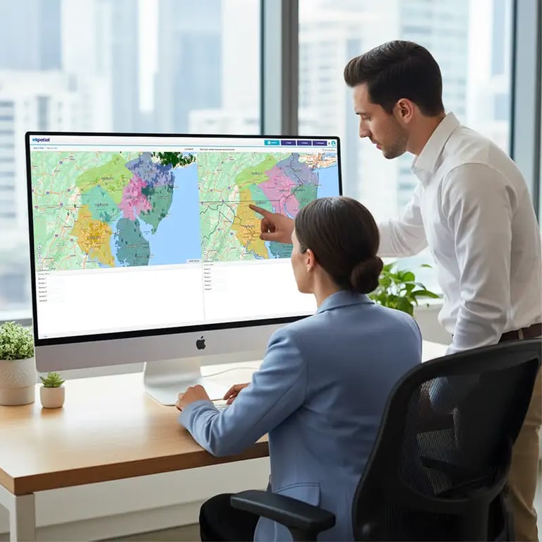
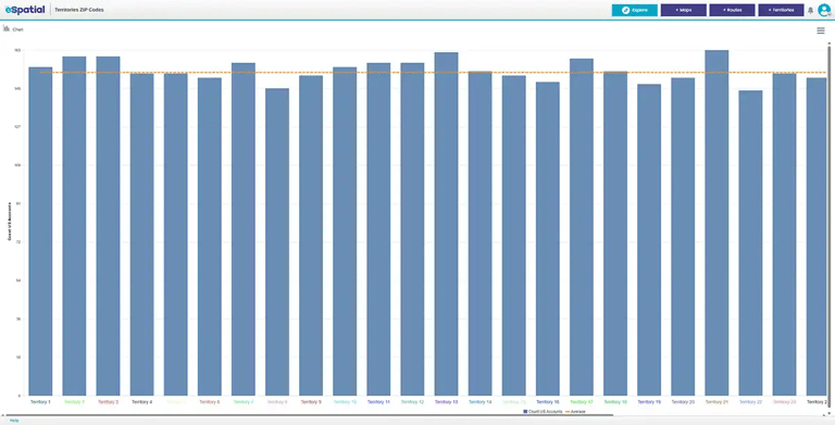
How do imbalanced territories undermine field rep productivity?
When territories are created without clear geographic boundaries or workload balancing, field reps spend more time navigating long drives than meeting clients. A rep might drive past several high-value accounts assigned to a colleague in another district simply because boundary lines were drawn arbitrarily. This structural disconnect results in excessive road time, missed sales opportunities, and friction within the team.

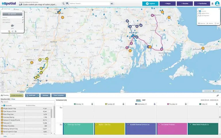
Why is an all-in-one mapping, territory design, and routing platform superior?
Optimizing a driving route within an unbalanced territory only streamlines an inefficient plan. eSpatial solves this by combining territory alignment, account visualization, and route optimization into a single unified workflow. By plotting your client location details and historical sales performance onto an interactive map, sales operations teams can balance workloads before generating daily routes. Reps receive logical itineraries that maximize meeting density, eliminate duplicate coverage, and protect selling hours.
How Do You Filter and Map
High-Value Leads for Field Reps?
eSpatial plots historical sales data onto interactive maps, allowing sales teams to filter prospects by location, priority level, account type, or last visit date. This visual mapping helps field reps focus daily itineraries on high-probability opportunities rather than spending time on low-value stops.
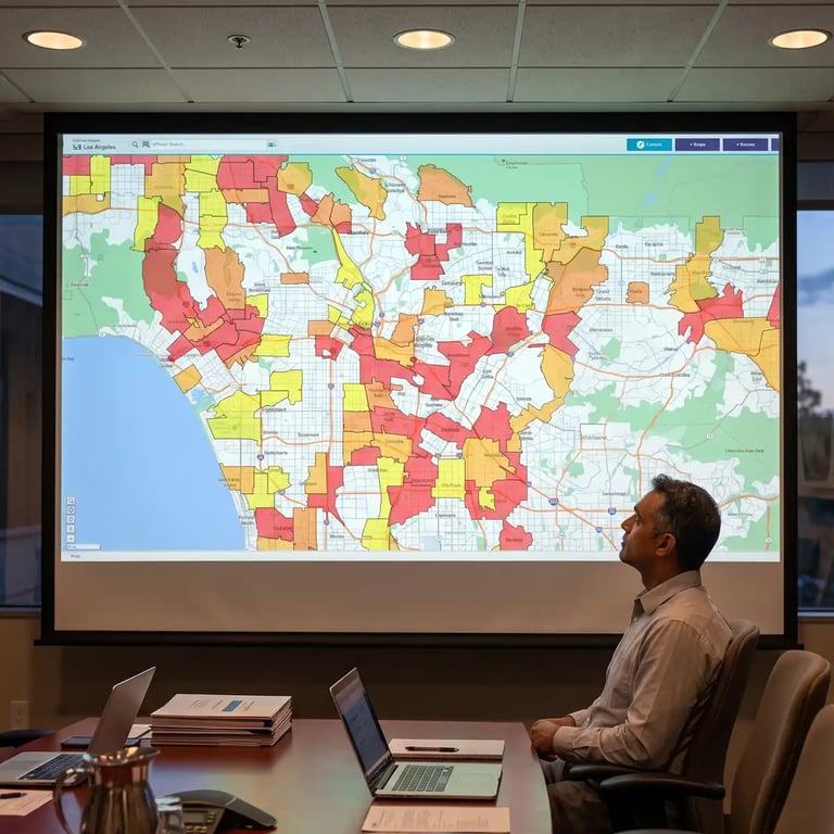
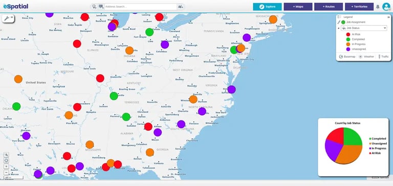
How can reps turn raw sales data into prioritized visual maps?
Spreadsheets filled with customer addresses and account details make it difficult to identify where the best revenue opportunities lie. By importing client records directly into eSpatial, sales teams instantly convert static spreadsheets into dynamic, color-coded interactive maps. Reps can quickly apply custom filters to segment accounts based on priority, recent meeting history, or sales volume. This allows reps to construct daily itineraries focused strictly on high-potential prospects, turning unstructured customer lists into clear, prioritized daily schedules.

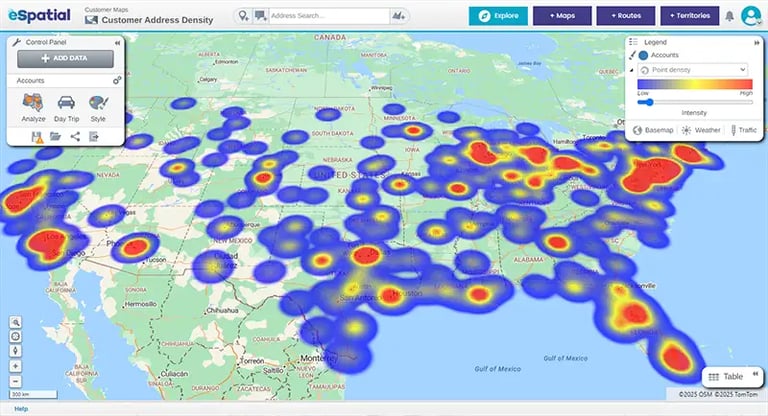
How do client heatmaps reveal hidden sales opportunities?
Visualizing customer density across a territory highlights geographic clusters of high-value accounts that standard lists mask. Heatmaps pinpoint areas with dense account concentration, helping reps target high-yield regions during weekly trip planning. When an appointment wraps up early or a prospect reschedules, reps can glance at the map to instantly identify nearby opportunities. This keeps field reps continuously active in high-density areas, cutting unnecessary drive times while maintaining consistent client coverage.
How Do Advanced Territory Alignments
Support Complex Sales Structures?
eSpatial's Advanced Territory Manager provides geographic, points-based, and hybrid territory alignments to manage complex field sales structures. While geographic boundaries prevent regional friction, points-based alignment enables strategic, intentional account overlap, allowing multi-product sales teams to serve shared clients without internal channel conflict.

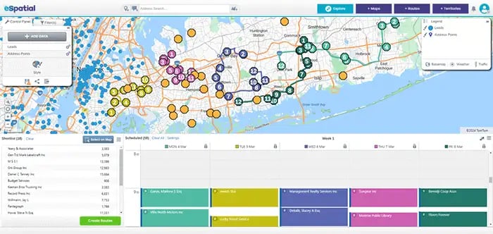
How do points-based territories keep multi-product routes efficient?
Rather than forcing reps into rigid map borders that cause detour-heavy driving, points-based alignment ties route planning directly to individual account locations and client priorities. This keeps daily schedules compact and logical, ensuring reps aren't forced to cross arbitrary county lines or bypass key clients on their way to a meeting.
Field reps get predictable, highly dense daily routes that save travel time while servicing the right accounts at the right frequency. By anchoring routes to account locations rather than physical borders, sales operations can maintain high meeting density even across complex territories.

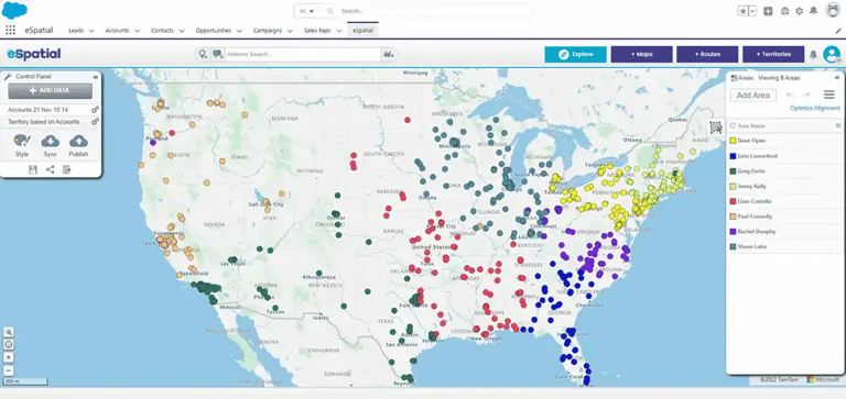
How can multi-product sales teams coordinate visits to the same account?
When separate reps sell distinct product lines to the same customer, rigid geographic borders can create internal confusion or limit overall revenue. Points-based (and hybrid) territory alignment supports intentional, structured account overlap across product lines. Reps from different divisions can visit identical customer locations without overriding account permissions or disrupting territory ownership. Shared visual territory maps bring complete clarity to multi-product organizations, eliminating duplicate visits while maximizing overall account growth.
What Is the Financial ROI of
Automated Sales Route Optimization?
Automating route optimization reduces field drive time by up to 30% and eliminates manual trip planning friction by 95%. Adding just 1 additional customer visit per day generates over $1,000 in net business value per rep monthly while significantly reducing fleet fuel and travel expenses.

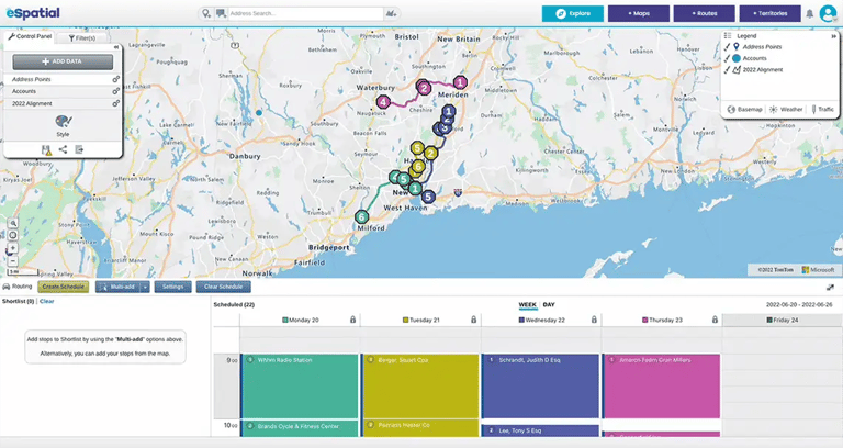
How much driving time can field sales reps save every week?
Field sales representatives often spend hours every week manually plotting stops or navigating inefficient driving routes. eSpatial’s routing engine calculates the fastest sequential path between client accounts, cutting overall weekly driving time by up to 30%. By reducing road time, reps reclaim several hours each week that can be redirected toward active prospect outreach and customer follow-ups. This efficiency shift turns wasted windshield time into productive, revenue-generating selling hours.

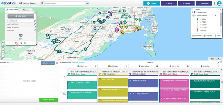
How does route automation reduce sales team travel expenses?
Inefficient routing directly inflates team travel costs through unnecessary mileage, excessive fuel consumption, and higher vehicle wear. Automated sales route optimization ensures reps take the most direct path between scheduled appointments, eliminating extra miles across every trip. When sales reps add just one additional face-to-face meeting to their daily schedule, a team of ten reps generates roughly 200 extra customer visits per month. This increased meeting density delivers substantial revenue upside while simultaneously driving down overall operating expenses and fleet fuel bills.
How Does Mobile Dynamic Re-Optimization
Handle Schedule Changes?
When an appointment gets canceled, eSpatial’s mobile dynamic re-optimization allows reps to adjust their schedules instantly on the road. Reps can locate nearby high-value prospects, re-sequence daily stops, and recalculate the fastest route to fill open calendar gaps without losing selling hours.

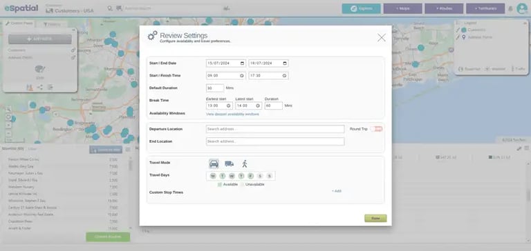
What should sales reps do when an appointment gets canceled in the field?
Last-minute cancellations often leave field reps stranded with unexpected downtime and wasted travel time. With eSpatial, reps can instantly filter nearby accounts directly from their mobile devices to identify priority prospects in the immediate area. Adding a replacement stop automatically recalculates the optimal driving route between appointments. Reps protect their daily meeting targets and turn unexpected schedule gaps into productive client conversations.
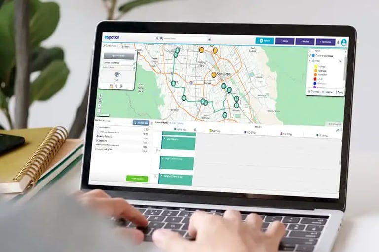
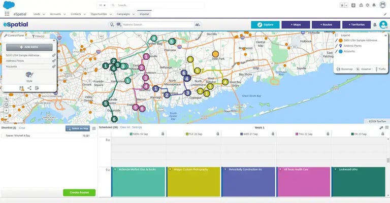
How does automated activity logging keep field records updated through Salesforce?
Logging meeting notes manually at the end of a long day creates administrative friction and leads to incomplete records. Through eSpatial’s Salesforce integration, field reps can record visit details and update account status directly from the road. Centralizing customer information ensures office staff and field reps stay completely synchronized with accurate, up-to-date sales data. Sales leaders gain immediate visibility into field activities, meeting durations, and route performance without imposing extra paperwork on reps.
Trusted by Businesses Globally
Join the leaders. Top teams across every industry use location intelligence to turn data into a competitive advantage. Sales: Hunt high-potential leads and balance territories. Operations: Optimise coverage and slash service costs. Marketing: Target high-growth regions and prove ROI.
★★★★★
eSpatial is Awesome
I have been using eSpatial for about a month and find it way more than I expected. Being able to easily utilize the system and visually seeing where incidents occur has helped us utilize resources more efficiently. The Customer Service is excellent.

★★★★☆
eSpatial is a great visual tool for mapping out leads, prospects, and current accounts
I appreciate the visual representation of all of the accounts and being able to connect the accounts with different filters and tools such as heat maps. It is a great organizational tool.
★★★★★
Great tool for creating custom maps and charts
This is a great tool for creating custom heat maps with our data. The CSV import makes it easy to upload and change data, and every point can show different markers. Very helpful for last minute presentations as well!

★★★★☆
Great tool for visualizing territories
We are able to send direct links to end users so they can visualize their areas of responsibility. Making changes to existing territories is very easy.
★★★★★
You must have no doubts, you must try
It is really very functional and effective for situations that require accurate data mapping. I like that I only have a little more than 20 days using it and I already feel like an expert. In addition, I love that I can establish effective data parameters to execute heat maps in a precise and personalized way.
★★★★★
Great Product!
This product is great and super easy to use. This has cut our route design timing in half. The customer service is fantastic!
★★★★★
The support is AMAZING and the tool is simple to use and works well!
The support is amazing. They reply right away every time! I have had two issues that needed resolution within an hour and their support team came through on both times.
★★★★★
Data Visualization Uncovers New Opportunities
The reason we selected and continuously renew our account is the outstanding support we receive each step of the way. eSpatial invests in your success and wants you to be getting the most out of their platform.
★★★★★
eSpatial is a lifesaver!
I have had nothing but success with eSpatial. When previous products were limited in their abilities (map sharing, dynamic maps, etc.).
★★★★☆
Engel & Völkers Americas
At E&V we use this software as a sales tool to show prospects their "territory" first hand. We also are able to create maps using address points to make it easier for our sales team to navigate larger areas of the US to make better use of their time.
★★★☆☆
Easy to use limited in customization
How easy the program is to learn. Easy to import new data.
★★★★☆
Great tool to help our non-profit plan
We appreciate the ability to layer multiple variables at a time.
★★★★★
User Friendly Mapping
I love how easy it was to learn how to map on this software. The set-up was not difficult either and they had a representative reach out personally to help you with your account whether you wanted a phone call or email help.
★★★★★
Great Collaborative platform!
I run a small team that responds to inbound leads with the purpose of qualifying and setting up meetings for our Sales partners. With the higher volume and tight turnaround times we deal with, a collaborative plugin like eSpatial is invaluable.
★★★★★
Bulletproof - Program And People
The program works flawlessly. It's so easy to add data, change the view, isolate territories - total flexibility.
★★★★☆
Excellent Data Visualisation
Ability to customise heat maps and overlay multiple data sets.
★★★★★
Fantastic product and service
This system provides a tremendous insight into our trading locations to allow us to make dynamic decisions. The team and after sales care are in keeping with the systems quality.
★★★★☆
Great program that's simple to use
eSpatial is very user-friendly, allowing us to spend little time implementing and training how to use the software. When we had issues, their excellent customer service was quick to respond.
★★★★★
Most User Friendly Mapping Tool & White Glove Customer Service!
Constant tool enhancements, extremely helpful & quick customer support, user friendly / great UI, easy to upload data, territory balancing option quick to learn / no implementation needed.
★★★★★
eSpatial is Awesome
I have been using eSpatial for about a month and find it way more than I expected. Being able to easily utilize the system and visually seeing where incidents occur has helped us utilize resources more efficiently. The Customer Service is excellent.
★★★★☆
eSpatial is a great visual tool for mapping out leads, prospects, and current accounts
I appreciate the visual representation of all of the accounts and being able to connect the accounts with different filters and tools such as heat maps. It is a great organizational tool.
★★★★★
Great tool for creating custom maps and charts
This is a great tool for creating custom heat maps with our data. The CSV import makes it easy to upload and change data, and every point can show different markers. Very helpful for last minute presentations as well!
★★★★☆
Great tool for visualizing territories
We are able to send direct links to end users so they can visualize their areas of responsibility. Making changes to existing territories is very easy.
★★★★★
You must have no doubts, you must try
It is really very functional and effective for situations that require accurate data mapping. I love that I can establish effective data parameters to execute heat maps in a precise and personalized way.
★★★★★
Great Product!
This product is great and super easy to use. This has cut our route design timing in half. The customer service is fantastic!
★★★★★
The support is AMAZING and the tool is simple to use and works well!
The support is amazing. They reply right away every time! I have had two issues that needed resolution within an hour and their support team came through on both times.
★★★★★
Data Visualization Uncovers New Opportunities
The reason we selected and continuously renew our account is the outstanding support we receive each step of the way. eSpatial invests in your success and wants you to be getting the most out of their platform.
★★★★★
eSpatial is a lifesaver!
eSpatial has set out to crush it from day one. Any improvement that I've suggested has eventually been implemented, and the customer service/support is TOP NOTCH.
★★★★☆
Engel & Völkers Americas
At E&V we use this software as a sales tool to show prospects their "territory" first hand. We also are able to create maps using address points to make it easier for our sales team to navigate larger areas of the US to make better use of their time.
★★★☆☆
Easy to use limited in customization
How easy the program is to learn. Easy to import new data.
★★★★☆
Great tool to help our non-profit plan
We appreciate the ability to layer multiple variables at a time.
★★★★★
User Friendly Mapping
I love how easy it was to learn how to map on this software. The set-up was not difficult either and they had a representative reach out personally to help you with your account whether you wanted a phone call or email help.
★★★★★
Great Collaborative platform!
I run a small team that responds to inbound leads with the purpose of qualifying and setting up meetings for our Sales partners. With the higher volume and tight turnaround times we deal with, a collaborative plugin like eSpatial is invaluable.
★★★★★
Bulletproof - Program And People
The program works flawlessly. It's so easy to add data, change the view, isolate territories - total flexibility.
★★★★☆
Excellent Data Visualisation
Ability to customise heat maps and overlay multiple data sets.
★★★★★
Fantastic product and service
This system provides a tremendous insight into our trading locations to allow us to make dynamic decisions. The team and after sales care are in keeping with the systems quality.
★★★★☆
Great program that's simple to use
eSpatial is very user-friendly, allowing us to spend little time implementing and training how to use the software. When we had issues, their excellent customer service was quick to respond.
★★★★★
Most User Friendly Mapping Tool & White Glove Customer Service!
Constant tool enhancements, extremely helpful & quick customer support, user friendly / great UI, easy to upload data, territory balancing option quick to learn / no implementation needed.
★★★★★
eSpatial is a very easy to use mapping tool for various business needs
Easy to upload data and format maps. Heat maps give us a quick view of our business and the radius and filters help us make business decisions.
★★★★★
eSpatial has been a great partner and their platform helps us in many aspects of sales planning
A great onboarding/training program helps hit the ground running. The dedicated success team is quick to respond, takes feedback, and continues to check in on our needs.
★★★★★
eSpatial is easy to use, maps are visually appealing, and the customer support is fantastic
Any time I have had a question or concern, the support team has responded very quickly and addressed all of my needs with the software.
★★★★☆
Great integration options & helpful support team
The ability to route at a postal code level and layer it among other data.
★★★★★
Wonderful application!
The ease of use and system functionality allow you to generate customized maps.
★★★★☆
Easy to use mapping and territory creator for logistics company
eSpatial is extremely easy to use when it comes to creating maps or territories. We utilize this to keep up with and modify the areas in which we service our customers.
★★★★★
Very Easy and Intuitive
I like the ability to be able to easily plan my routes for my sales calls. It helps me make the most of the time I have and the miles I drive, and allows me to hit my goals more easily than if I were just flying by the seat of my pants.
★★★★★
Great Customer Support
The customer support is fantastic. I wish that every company serviced their customers like eSpatial.
★★★★★
Advancing Your Business Development and Growth
I like best about eSpatial is the ease of the tool and support from the eSpatial team.
★★★☆☆
Use eSpatial for simple policy mapping
Updates to maps in my eSpatial account automatically sync to the webpages where I have them linked.
★★★★★
Mapping
The ability to slice a data set into different maps and share them with non-licensed users.
★★★★☆
Good Mapping System for Corporate Customers
I like the user interface and how you can manipulate the layers and appearances of the maps.
★★★★★
Great Out of The Box UI and Fantastic Customer Support
Easy to map and design territories; clean UI.
★★★★★
Great product
Excellent reaction time, accuracy, customer service.
★★★★★
eSpatial Was Definitely the Right Choice for my Company
User-friendly, powerful, visually attractive, accurate, with robust data integration.
★★★★★
Amazing Product. Otherwordly Support
I use eSpatial to plot sales by zip codes for retailers and their competitors. The mapping helps me to better focus digital advertising, decide y/n on cable zones, and to measure effectiveness of changes in media plans. Clients love it, because . . . well, the map has life. A spreadsheet does not.
★★★★☆
There was a change in the website design but I preferred the old one
Something that is good about eSpatial is for planning proximity purposes, it is a good tool.
★★★★★
A Great Tool for Mapping Customers and for Marketing
The ease of use. The platform makes uploading data and mapping extremely easy. This is not limited to just customer data.
★★★★★
Strategic Mapping of College Sports Fans
Visualizing the data through heat maps or radius maps allows me to tell a positive story that is easy to comprehend.
★★★★★
eSpatial is a very easy to use mapping tool for various business needs
Easy to upload data and format maps. Heat maps give us a quick view of our business and the radius and filters help us make business decisions.
★★★★★
eSpatial has been a great partner and their platform helps us in many aspects of sales planning
A great onboarding/training program helps hit the ground running. The dedicated success team is quick to respond, takes feedback, and continues to check in on our needs.
★★★★★
eSpatial is easy to use, maps are visually appealing, and the customer support is fantastic
Any time I have had a question or concern, the support team has responded very quickly and addressed all of my needs with the software.
★★★★☆
Great integration options & helpful support team
The ability to route at a postal code level and layer it among other data.
★★★★★
Wonderful application!
The ease of use and system functionality allow you to generate customized maps.
★★★★☆
Easy to use mapping and territory creator for logistics company
eSpatial is extremely easy to use when it comes to creating maps or territories. We utilize this to keep up with and modify the areas in which we service our customers.
★★★★★
Very Easy and Intuitive
I like the ability to be able to easily plan my routes for my sales calls. It helps me make the most of the time I have and the miles I drive, and allows me to hit my goals more easily than if I were just flying by the seat of my pants.
★★★★★
Great Customer Support
They ask the right questions to get an understanding of what you need to accomplish with the software. Their overall knowledge of the practical way to use the software of the software is phenomenal.
★★★★★
Advancing Your Business Development and Growth
I like best about eSpatial is the ease of the tool and support from the eSpatial team.
★★★☆☆
Use eSpatial for simple policy mapping
Updates to maps in my eSpatial account automatically sync to the webpages where I have them linked.
★★★★★
Mapping
The ability to slice a data set into different maps and share them with non-licensed users.
★★★★☆
Good Mapping System for Corporate Customers
I like the user interface and how you can manipulate the layers and appearances of the maps.
★★★★★
Great Out of The Box UI and Fantastic Customer Support
Easy to map and design territories; clean UI.
★★★★★
Great product
Excellent reaction time, accuracy, customer service.
★★★★★
eSpatial Was Definitely the Right Choice for my Company
User-friendly, powerful, visually attractive, accurate, with robust data integration.
★★★★★
Amazing Product. Otherwordly Support
I use eSpatial to plot sales by zip codes for retailers and their competitors. The mapping helps me to better focus digital advertising, decide y/n on cable zones, and to measure effectiveness of changes in media plans. Clients love it, because . . . well, the map has life. A spreadsheet does not.
★★★★☆
There was a change in the website design but I preferred the old one
Something that is good about eSpatial is for planning proximity purposes, it is a good tool.
★★★★★
A Great Tool for Mapping Customers and for Marketing
The ease of use. The platform makes uploading data and mapping extremely easy. This is not limited to just customer data.
★★★★★
Strategic Mapping of College Sports Fans
Visualizing the data through heat maps or radius maps allows me to tell a positive story that is easy to comprehend.