Geo mapping software


Power geo mapping for marketing, sales and operations

Sign up for a free 14-day trial
Geo map, pins over a regional heatmap
What is geo mapping
Video transcript for What is geo mapping

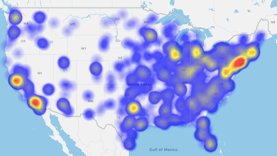
Geo-mapping is a powerful tool for creating maps using location data like sales numbers or demographics. It's a tool lets you easily interpret trends in your data.

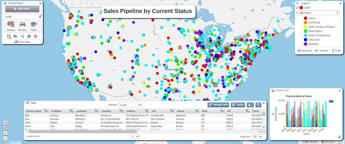
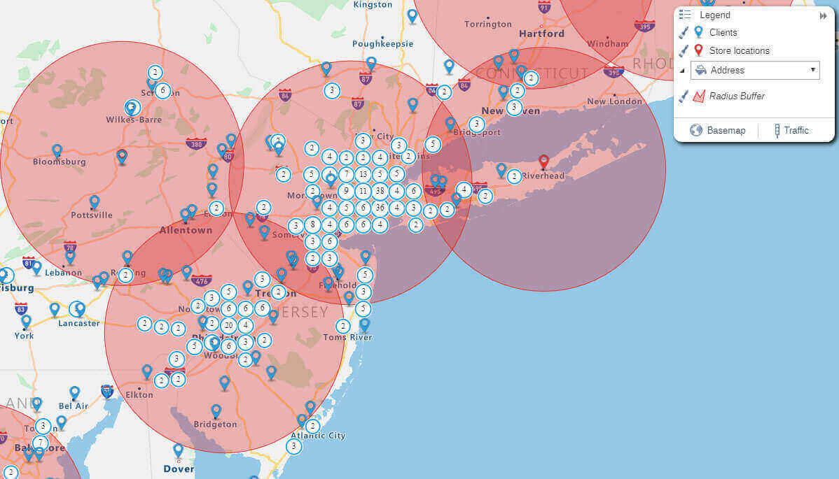
For example, I want to filter to just the Chicago area. And I want to narrow my analysis to just those with a higher sales potential than $10,000.

So now I can reveal all of those points. But I want to hide some of the points, the ones below 5, 7, 10 and a half etc.

So only highlight the ones with $15,000 and above. And now I can see the locations and click on a pin to get customer details.


What is geo mapping?

Geo-mapping is the process of creating a map from raw, location-based data such as names, sales numbers, and demographics. By visualizing location data on maps, you immediately understand trends and new opportunities that could otherwise take hours to interpret.

There are many types of geo maps, each serving a different purpose. eSpatial can help you make the right geo map to meet your needs, whether a simple pin map or creating sales territories based on client density. You access professional geo mapping software to take spreadsheet information and generate the map most suited to analyzing your data.

Why you should geo map your business data

1. Build field sales or service territories

Create optimized sales and service territories that ensure the efficient use of field resources. Use territory mapping software to balance by the number of customers, sales potential, workload, area, and much more.

2. Sales and service coverage maps

Radius and drive time buffers can help you find gaps or overlaps in your sales or service coverage areas, ensuring you're maximizing your resources and maximizing sales and service calls and revenue.

3. Market analysis and intelligence

Understand your customer locations and identify potential areas for future sales growth or new service areas. It can help you decide the best place to open a new location, where the most high-value sales prospects are, and more.

4. Intelligent route planning

Once you've mapped your business data, you can save time and money with intelligent route planning and optimization. Plan your day and maximize your time on the road with geo mapping.

5. Sales reporting and analysis

Instantly see and compare sales and service performance across regions. Geo mapping is a quick and easy way to analyze and present this information at a glance.

How do I create a geo map?

You can start geomapping in minutes with a free seven-day trial of eSpatial, which includes full access to its professional features. Make your first map today by following these simple steps:

1. Sign up for a free trial

First, sign up for a free trial with a business email and create a password.

Free trial form

Once you've logged in to your trial, you'll be given four map options. Choose Pin Map for starters. Next, you have the option to use our example data, choose data from our library or upload your own. To prepare your own location data, make sure the columns in your spreadsheet include unique headings, such as address, city and state. Save your data in Excel (XLS) or CSV format before uploading. Check out our how-to guide for more tips on formatting your data.

Once you've uploaded, eSpatial will automatically choose the relevant headings. If you need to adjust the information, click “Change Settings.” When you're ready to map, click “Complete.”

Prepared geo mapping data in an excel spreadsheet

eSpatial will use the data you entered to create a pin map, and that’s just the beginning. Let’s look at what type of geo maps you can create now that you’ve uploaded your location data to eSpatial.

Color coded pin map


What kind of geo map can I make?

Pin geo map

1. Pin maps


Pin maps are the simplest way to plot your data. They are perfect for identifying customer locations and can be styled and color-coded based on different properties, such as a customer's average purchase value. It allows you to see where your most valuable customers live.

Learn more about pin maps
Heat map

2. Heat maps


This type of geo map lets you quickly see pockets of density. Use heat maps to identify high and low-performing sales or service territories rapidly. For example, insurance companies use heatmaps to identify areas that have a high number of insurance claims.

Learn more about heat maps
US territory map

3. Territory maps


Any company with a field sales team needs to consider territory mapping. It can help create equitable and profitable regions for your field sales and service teams. It eliminates accidental overlap, ensuring sales reps pay enough attention to leads and improves employee satisfaction.

When combined with route optimization, territory mapping can also help your sales reps make the most of their time on the road daily, leading to lower fuel costs and higher sales.

Learn more about territory maps
Radius map

4. Radius maps


With eSpatial, you can create radius geo maps based on distance or drive time. Radius maps excel when deciding where to open your next franchise or office or when plotting the right coverage for a service technician, or assigning accounts to field sales reps.

Learn more about radius maps

Why choose eSpatial for geo mapping?

eSpatial is the ideal software for data analysts, sales analysts, sales operations, marketing, and operations teams, giving you robust analysis and support to help you reach primary organizational goals.

Here are just a few key features:

  • Fully integrated platform: Access advanced mapping, territory, and route optimization software on the complete mapping software platform.
  • Range of geo mapping tools: Map data in multiple ways to suit particular business goals. Heatmaps, bubble maps, zip code maps, drivetime, and radius maps are included.
  • Built-in datasets: Access more than 100 boundary and demographic data sets to plot and compare with your data.
  • Easy-to-use solution: No experience necessary. It's fast, easy, and powerful. You can upload and map your data in seconds.
  • Full training and support: If you need help, we provide outstanding support, including live chat, video tutorials, how-to guides, and one-on-one support sessions.
  • Enterprise-level security: Enterprise ready, secure, and scalable.