4.8/5 of 53 reviews
4.3/5 of 38 reviews

Why Sales Operations Teams Are Transitioning from Microsoft MapPoint to eSpatial


The limitations of legacy desktop mapping vs. modern spatial intelligence

Radius map of USA

Our Customers Love Mapping With eSpatial

  • RE/MAX logo
  • FedEx logo
  • Volvo logo
  • LG Electronics logo
  • Henkel Corporation logo
  • Continental Tire logo

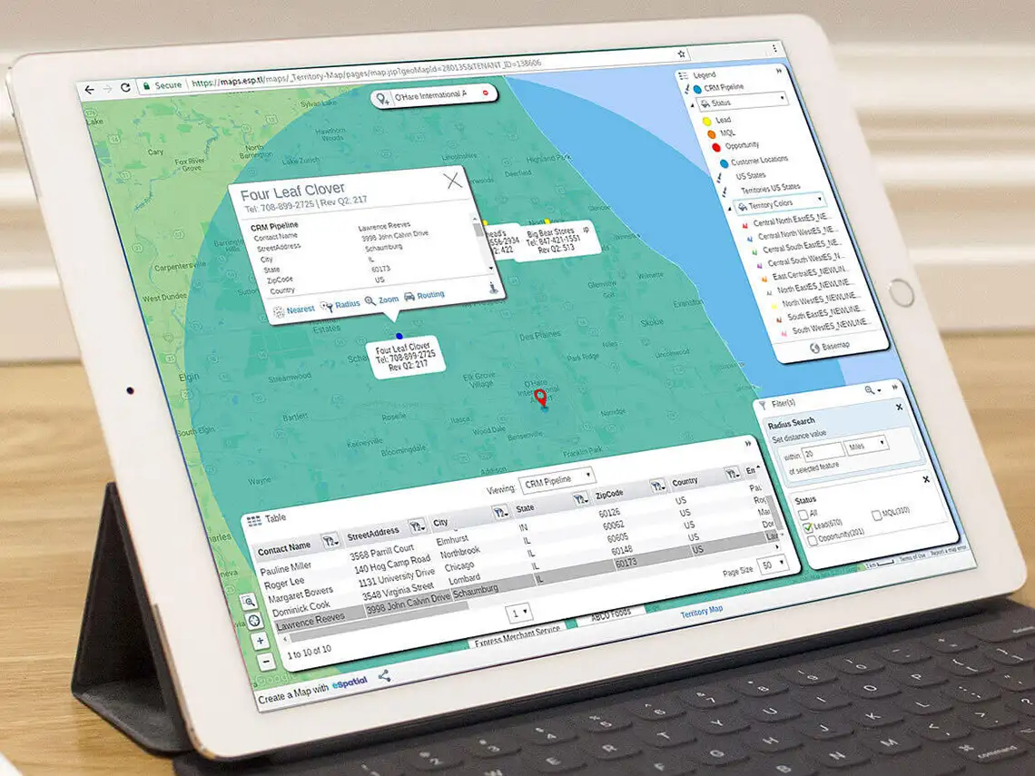
Microsoft MapPoint was a foundational desktop mapping application discontinued by Microsoft in 2014. Today, Sales Ops and operations teams use eSpatial as the premier MapPoint alternative because it transitions static offline data into a secure, cloud-based geographic decision-engine to:

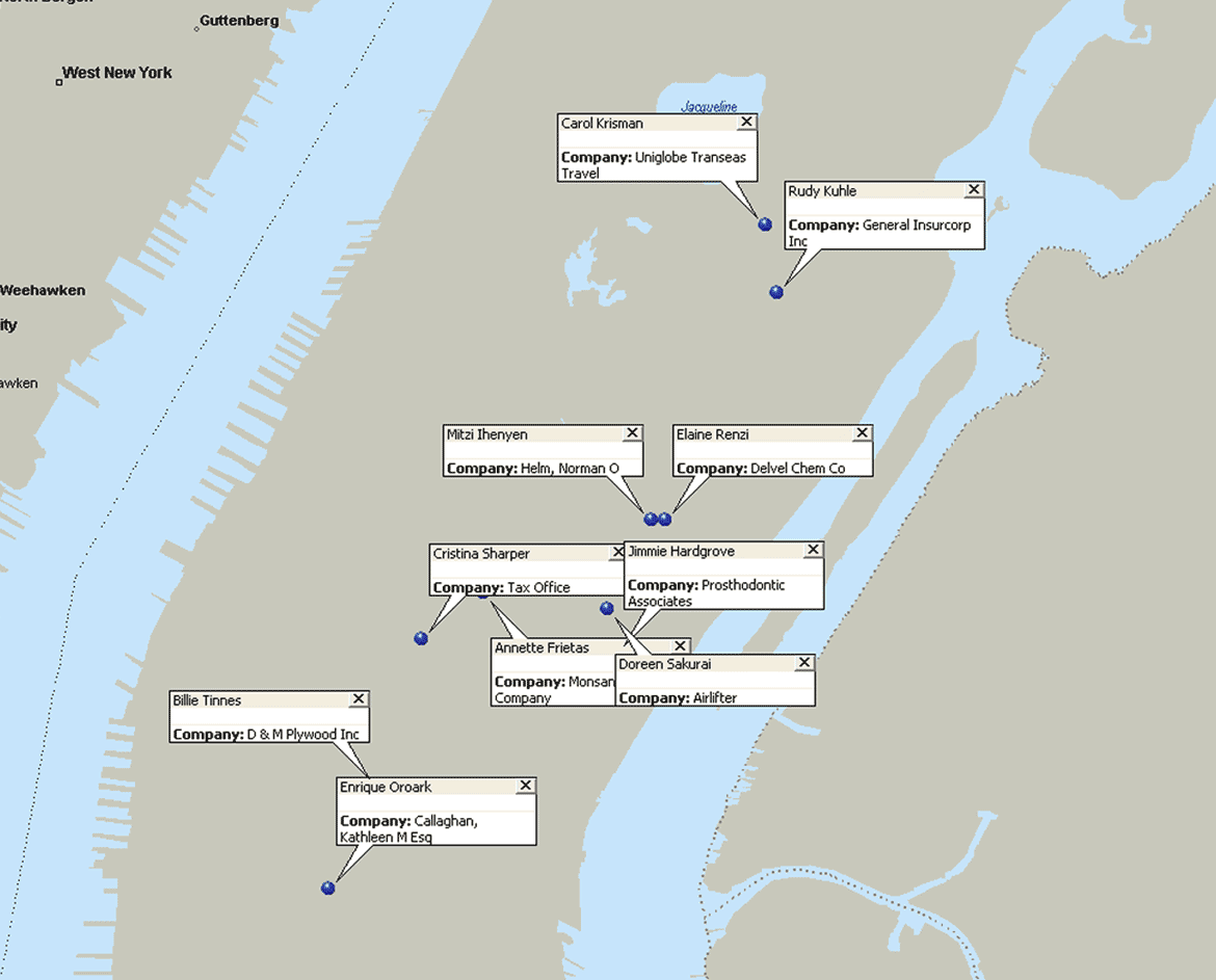
  • Plot Excel datasets instantly: Upload raw spreadsheet and CRM lists to generate interactive pin maps, radius reports, and heatmaps in seconds with zero GIS coding required
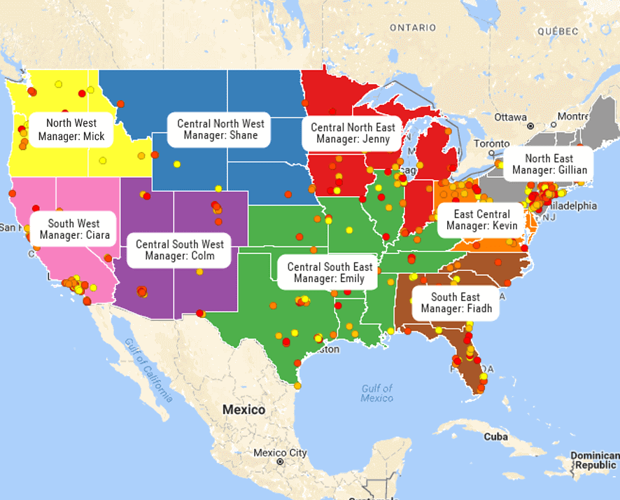
  • Model dynamic "what-if" scenarios: Securely balance complex, 6-level sales organizational hierarchies during live alignment sessions to protect representative morale and eliminate territory overlap
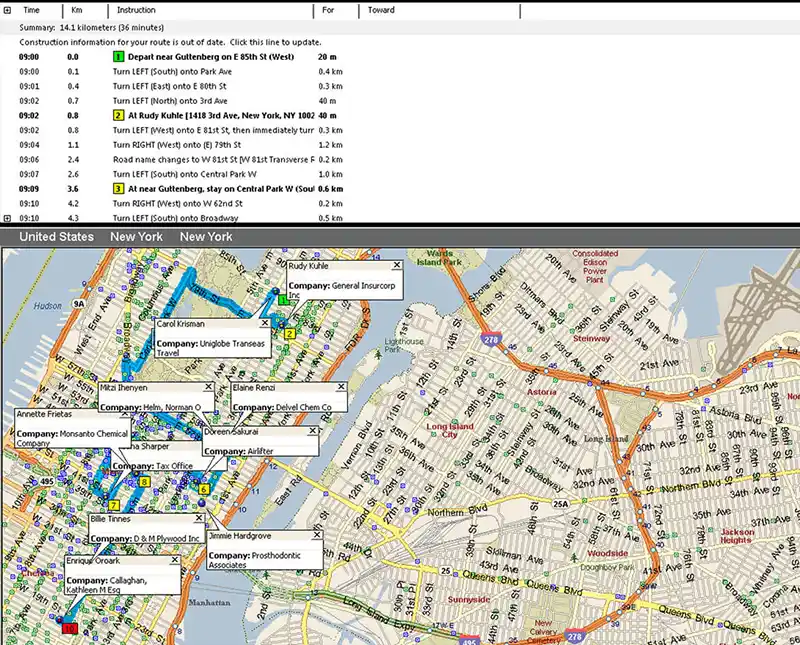
  • Optimize field team routing: Build automated multi-stop daily route plans that slash driver windshield travel time by 30% and increase customer meetings by 20%

What to Look for in a MapPoint Alternative


Stop searching. Replace Microsoft’s discontinued software with the cloud-based leader in territory mapping. You shouldn't have to sacrifice functionality for modernity. We kept the powerful territory tools you loved in MapPoint—but added the speed, sharing, and visualisation power of the cloud. Go deeper with our mapping software.

Do More Than MapPoint


eep the workflows you rely on. From sales territories to emergency response, we cover every use case MapPoint handled, but we do it faster and in the cloud.

Who It's For

  • Sales & Marketing: Pinpoint targets and balance territories
  • Logistics: Optimize routes and track operations
  • Analysts: Visualize complex data instantly

A feature-by-feature comparison proves eSpatial isn't just a replacement—it is a significant upgrade for your entire organisation.

Feature

Microsoft MapPointLegacy Offline Software

eSpatialModern Cloud Mapping Platform

Platform Architecture

Static offline desktop installation (Discontinued in 2014)

Secure, cloud-based mapping platform ready on day one

Data Integration

Manual import of static, offline Excel files only

Seamless Salesforce bidirectional connector and automated CRM syncing

Territory Management

Basic geographic boundary drawing with zero optimization

Advanced automated territory balancing based on workload, revenue, and active CRM pipelines

Mobile Routing

None (Static offline map printouts)

Mobile-friendly optimization app with real-time midday re-routing for reps

Organizational Scaling

Restricted to flat, single-layer maps

Secure 6-level organizational hierarchies mirroring your actual sales structure

Professional Services

Required expensive custom setups for complex maps

Zero professional services or IT lift required; onboarding and training are included

Core Features, Upgraded


Keep the capabilities you relied on in MapPoint—now optimized for the modern cloud. We paired powerful mapping with a simple, intuitive interface. Legacy software slows you down. We built a seamless alternative that combines deep functionality with the speed and ease your business demands.

1. Map Anywhere, in Minutes

Access your maps on any device—desktop, tablet, or mobile—with zero installation required. We store everything securely in the cloud, allowing your team to collaborate, update, and share insights in real time.

The Capabilities

  • Connect data: Seamless integration with Salesforce
  • Collaborate: Share live maps and annotations instantly
  • Stay secure: Your data is automatically backed up and always current

2. Map on Any Device

Break free from the desktop. View, edit, and share your maps instantly on a PC, Mac, tablet, or smartphone. MapPoint limited you to a single licensed installation. We operate in the cloud, so you are never office-bound and your critical data is always within reach.

3. Visualize Data Instantly

Plot, layer, and style your business data with greater flexibility and clarity than MapPoint ever offered. Static spreadsheets hide the story. Our advanced tools let you spot trends and gather insights in seconds, not hours.

The Toolkit

  • Heat maps: Instantly identify density and hotspots
  • Smart styling: Use size and symbol-by-value options to make outliers pop
  • Base maps: Choose the perfect backdrop to bring your data to life

Get Started With eSpatial Today


Our team is here to help you every step of the way

4. Optimize Routes Instantly

Turn a list of stops into the most efficient path in seconds. Set your start, end, and break times, then let our software do the heavy lifting. We ensure your team spends more time with customers and less time looking at the windshield.

The Tools

  • Plan ahead: Schedule routes up to 20 days in advance
  • Navigate your way: send turn-by-turn directions directly to Google Maps, Apple Maps, or Waze
  • Collaborate: Export and share routes with your team instantly

5. Master Your Territories

Build, balance, and analyze sales territories with a level of precision MapPoint couldn't match using Territory management. Imbalanced territories hurt sales performance. We help you distribute workload fairly and optimize based on real data—without starting from scratch.

The Capabilities

  • Optimize: Balance territories using a weighted work index
  • Delegate: Assign responsibility clearly based on hierarchy
  • Migrate: Upload existing MapPoint files instantly so you never lose work

Why Teams Choose eSpatial


MapPoint is discontinued. We offer the modern, cloud-based alternative built specifically for today's workflows.

Frequently Asked Questions


Yes. Upload your existing files directly to keep your territory and customer data intact.

Yes. Create, edit, and analyze territories instantly using ZIP or postal codes.

No. Access and edit your maps on the cloud only.

eSpatial is a significant upgrade over MapPoint. We replaced static planning tools with dynamic, automated optimization. Modern logistics require speed. We added multi-day planning and real-time collaboration so you can manage complex operations without the headache.

The Upgrade

  • Route: Optimize multi-day trips instantly to save fuel and time
  • Territory: Balance optimize and assign regions with drag-and-drop simplicity
  • Collaborate: Adjust plans together in real time, ensuring everyone stays aligned

Map in Minutes


Build your first map instantly. Visualize data and explore advanced routing tools with zero setup or installation. The best way to replace MapPoint is to see it in action. Test the speed, precision, and ease of eSpatial yourself, completely risk-free.

You appear to be offline at the moment, this notice will disappear once your device can connect to the internet again